You are here: Home > Network List > US - United States National Seismic Network Stations List
> Station DGMT Dagmar, Montana, USA > Earthquake Result Viewer
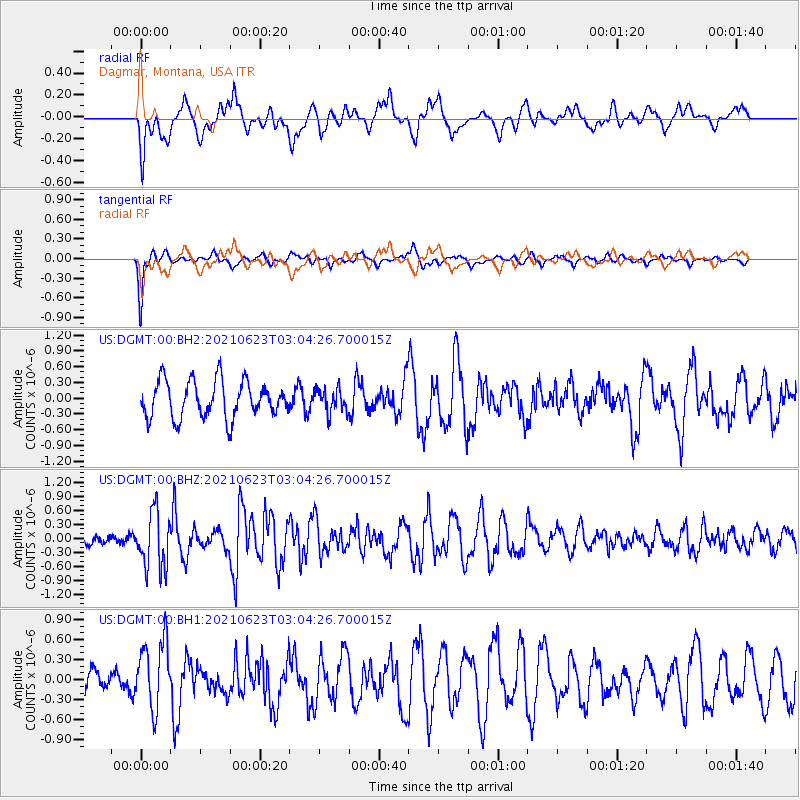
DGMT Dagmar, Montana, USA - Earthquake Result Viewer
*The percent match for this event was below the threshold and hence no stack was calculated.
| Earthquake location: |
Near Coast Of Peru |
| Earthquake latitude/longitude: |
-12.7/-76.7 |
| Earthquake time(UTC): |
2021/06/23 (174) 02:54:18 GMT |
| Earthquake Depth: |
51 km |
| Earthquake Magnitude: |
5.8 mww |
| Earthquake Catalog/Contributor: |
NEIC PDE/us |
|
| Network: |
US United States National Seismic Network |
| Station: |
DGMT Dagmar, Montana, USA |
| Lat/Lon: |
48.47 N/104.20 W |
| Elevation: |
0.0 m |
|
| Distance: |
65.6 deg |
| Az: |
340.295 deg |
| Baz: |
150.367 deg |
| Ray Param: |
$rayparam |
*The percent match for this event was below the threshold and hence was not used in the summary stack. |
|
| Radial Match: |
67.6128 % |
| Radial Bump: |
400 |
| Transverse Match: |
81.72203 % |
| Transverse Bump: |
360 |
| SOD ConfigId: |
25131211 |
| Insert Time: |
2021-07-07 03:18:11.063 +0000 |
| GWidth: |
2.5 |
| Max Bumps: |
400 |
| Tol: |
0.001 |
|
Signal To Noise
| Channel | StoN | STA | LTA |
| US:DGMT:00:BHZ:20210623T03:04:26.700015Z | 3.6741745 | 6.0558625E-7 | 1.648224E-7 |
| US:DGMT:00:BH1:20210623T03:04:26.700015Z | 2.8154461 | 5.078036E-7 | 1.8036346E-7 |
| US:DGMT:00:BH2:20210623T03:04:26.700015Z | 0.6369319 | 2.2214567E-7 | 3.487746E-7 |
| Arrivals |
| Ps | |
| PpPs | |
| PsPs/PpSs | |


