You are here: Home > Network List > US - United States National Seismic Network Stations List
> Station HAWA Hanford, Washington, USA > Earthquake Result Viewer
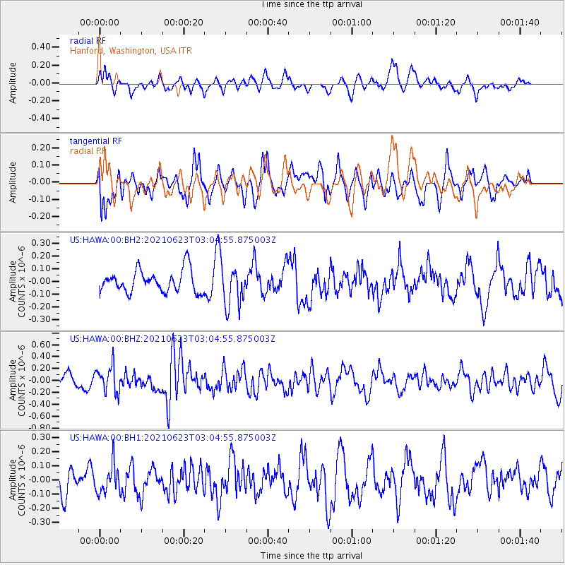
HAWA Hanford, Washington, USA - Earthquake Result Viewer
*The percent match for this event was below the threshold and hence no stack was calculated.
| Earthquake location: |
Near Coast Of Peru |
| Earthquake latitude/longitude: |
-12.7/-76.7 |
| Earthquake time(UTC): |
2021/06/23 (174) 02:54:18 GMT |
| Earthquake Depth: |
51 km |
| Earthquake Magnitude: |
5.8 mww |
| Earthquake Catalog/Contributor: |
NEIC PDE/us |
|
| Network: |
US United States National Seismic Network |
| Station: |
HAWA Hanford, Washington, USA |
| Lat/Lon: |
46.39 N/119.53 W |
| Elevation: |
364 m |
|
| Distance: |
70.2 deg |
| Az: |
330.014 deg |
| Baz: |
135.196 deg |
| Ray Param: |
$rayparam |
*The percent match for this event was below the threshold and hence was not used in the summary stack. |
|
| Radial Match: |
61.80936 % |
| Radial Bump: |
400 |
| Transverse Match: |
64.918274 % |
| Transverse Bump: |
400 |
| SOD ConfigId: |
25131211 |
| Insert Time: |
2021-07-07 03:18:21.878 +0000 |
| GWidth: |
2.5 |
| Max Bumps: |
400 |
| Tol: |
0.001 |
|
Signal To Noise
| Channel | StoN | STA | LTA |
| US:HAWA:00:BHZ:20210623T03:04:55.875003Z | 2.786149 | 2.2039798E-7 | 7.910487E-8 |
| US:HAWA:00:BH1:20210623T03:04:55.875003Z | 0.9057309 | 1.0149253E-7 | 1.1205594E-7 |
| US:HAWA:00:BH2:20210623T03:04:55.875003Z | 1.7500205 | 1.5326793E-7 | 8.7580645E-8 |
| Arrivals |
| Ps | |
| PpPs | |
| PsPs/PpSs | |


