You are here: Home > Network List > UW - Pacific Northwest Regional Seismic Network Stations List
> Station IRON Crane, OR, USA > Earthquake Result Viewer
IRON Crane, OR, USA - Earthquake Result Viewer
*The percent match for this event was below the threshold and hence no stack was calculated.
| Earthquake location: |
Near Coast Of Peru |
| Earthquake latitude/longitude: |
-12.7/-76.7 |
| Earthquake time(UTC): |
2021/06/23 (174) 02:54:18 GMT |
| Earthquake Depth: |
51 km |
| Earthquake Magnitude: |
5.8 mww |
| Earthquake Catalog/Contributor: |
NEIC PDE/us |
|
| Network: |
UW Pacific Northwest Regional Seismic Network |
| Station: |
IRON Crane, OR, USA |
| Lat/Lon: |
43.36 N/118.47 W |
| Elevation: |
1226 m |
|
| Distance: |
67.6 deg |
| Az: |
328.298 deg |
| Baz: |
135.322 deg |
| Ray Param: |
$rayparam |
*The percent match for this event was below the threshold and hence was not used in the summary stack. |
|
| Radial Match: |
64.48409 % |
| Radial Bump: |
351 |
| Transverse Match: |
56.020298 % |
| Transverse Bump: |
360 |
| SOD ConfigId: |
25131211 |
| Insert Time: |
2021-07-07 03:20:09.834 +0000 |
| GWidth: |
2.5 |
| Max Bumps: |
400 |
| Tol: |
0.001 |
|
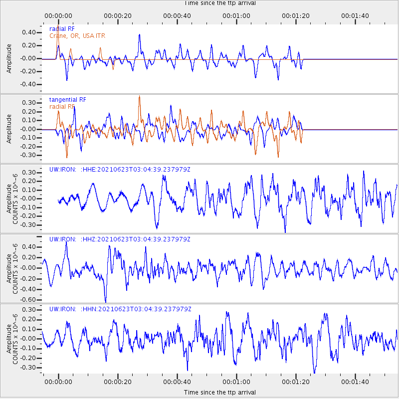
Signal To Noise
| Channel | StoN | STA | LTA |
| UW:IRON: :HHZ:20210623T03:04:39.237979Z | 3.290692 | 1.9212715E-7 | 5.8385027E-8 |
| UW:IRON: :HHN:20210623T03:04:39.237979Z | 1.5387567 | 8.901643E-8 | 5.784958E-8 |
| UW:IRON: :HHE:20210623T03:04:39.237979Z | 2.0549393 | 1.5063141E-7 | 7.330212E-8 |
| Arrivals |
| Ps | |
| PpPs | |
| PsPs/PpSs | |


