You are here: Home > Network List > GS - US Geological Survey Networks Stations List
> Station DEC06 Boomer > Earthquake Result Viewer
DEC06 Boomer - Earthquake Result Viewer
*The percent match for this event was below the threshold and hence no stack was calculated.
| Earthquake location: |
Southern East Pacific Rise |
| Earthquake latitude/longitude: |
-53.1/-117.4 |
| Earthquake time(UTC): |
2017/12/29 (363) 21:20:53 GMT |
| Earthquake Depth: |
10 km |
| Earthquake Magnitude: |
5.7 Mww |
| Earthquake Catalog/Contributor: |
NEIC PDE/us |
|
| Network: |
GS US Geological Survey Networks |
| Station: |
DEC06 Boomer |
| Lat/Lon: |
39.90 N/88.95 W |
| Elevation: |
215 m |
|
| Distance: |
95.8 deg |
| Az: |
21.628 deg |
| Baz: |
196.795 deg |
| Ray Param: |
$rayparam |
*The percent match for this event was below the threshold and hence was not used in the summary stack. |
|
| Radial Match: |
32.313503 % |
| Radial Bump: |
400 |
| Transverse Match: |
45.446533 % |
| Transverse Bump: |
400 |
| SOD ConfigId: |
2528331 |
| Insert Time: |
2018-01-12 21:22:21.057 +0000 |
| GWidth: |
2.5 |
| Max Bumps: |
400 |
| Tol: |
0.001 |
|
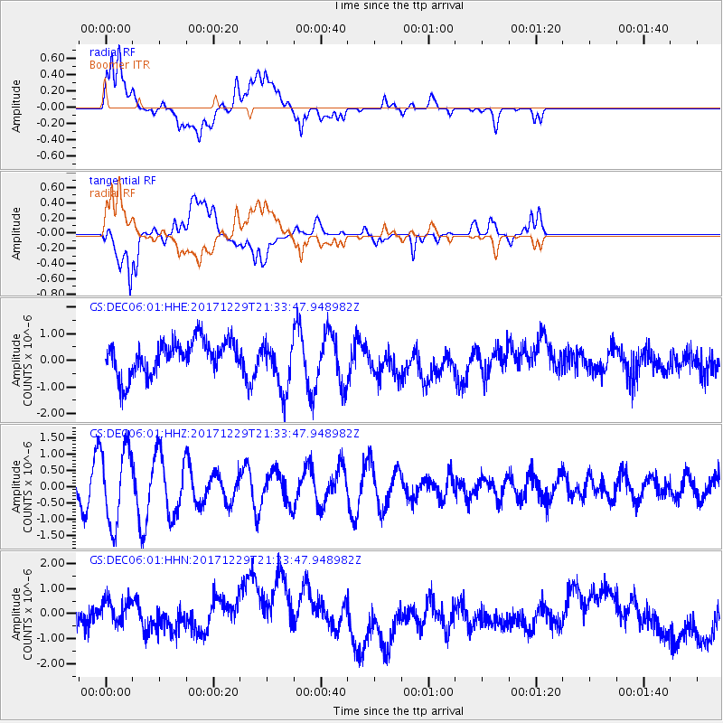
Signal To Noise
| Channel | StoN | STA | LTA |
| GS:DEC06:01:HHZ:20171229T21:33:47.948982Z | 2.3097804 | 1.1687191E-6 | 5.0598715E-7 |
| GS:DEC06:01:HHN:20171229T21:33:47.948982Z | 0.5142163 | 5.800257E-7 | 1.12798E-6 |
| GS:DEC06:01:HHE:20171229T21:33:47.948982Z | 1.5089444 | 9.586702E-7 | 6.353251E-7 |
| Arrivals |
| Ps | |
| PpPs | |
| PsPs/PpSs | |


