You are here: Home > Network List > AV - Alaska Volcano Observatory Stations List
> Station MAPS Pakushin Southeast, Makushin Volcano, Alaska > Earthquake Result Viewer
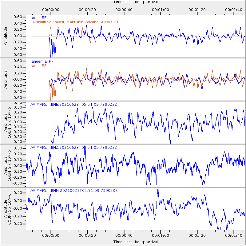
MAPS Pakushin Southeast, Makushin Volcano, Alaska - Earthquake Result Viewer
*The percent match for this event was below the threshold and hence no stack was calculated.
| Earthquake location: |
Southeast Of Loyalty Islands |
| Earthquake latitude/longitude: |
-22.8/171.7 |
| Earthquake time(UTC): |
2021/06/23 (174) 05:39:39 GMT |
| Earthquake Depth: |
10 km |
| Earthquake Magnitude: |
5.5 mb |
| Earthquake Catalog/Contributor: |
NEIC PDE/us |
|
| Network: |
AV Alaska Volcano Observatory |
| Station: |
MAPS Pakushin Southeast, Makushin Volcano, Alaska |
| Lat/Lon: |
53.81 N/166.94 W |
| Elevation: |
333 m |
|
| Distance: |
78.5 deg |
| Az: |
12.75 deg |
| Baz: |
200.083 deg |
| Ray Param: |
$rayparam |
*The percent match for this event was below the threshold and hence was not used in the summary stack. |
|
| Radial Match: |
72.21765 % |
| Radial Bump: |
400 |
| Transverse Match: |
52.91097 % |
| Transverse Bump: |
400 |
| SOD ConfigId: |
25131211 |
| Insert Time: |
2021-07-07 05:43:25.230 +0000 |
| GWidth: |
2.5 |
| Max Bumps: |
400 |
| Tol: |
0.001 |
|
Signal To Noise
| Channel | StoN | STA | LTA |
| AV:MAPS: :BHZ:20210623T05:51:09.739023Z | 1.3055712 | 1.8726551E-7 | 1.434357E-7 |
| AV:MAPS: :BHN:20210623T05:51:09.739023Z | 0.7007854 | 2.3144314E-7 | 3.302625E-7 |
| AV:MAPS: :BHE:20210623T05:51:09.739023Z | 1.1621864 | 2.0249173E-7 | 1.7423343E-7 |
| Arrivals |
| Ps | |
| PpPs | |
| PsPs/PpSs | |


