You are here: Home > Network List > AV - Alaska Volcano Observatory Stations List
> Station SPCR Ckakachatna River, Mount Spurr, Alaska > Earthquake Result Viewer
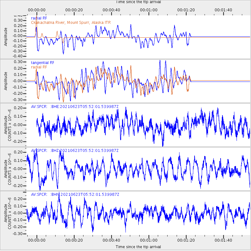
SPCR Ckakachatna River, Mount Spurr, Alaska - Earthquake Result Viewer
*The percent match for this event was below the threshold and hence no stack was calculated.
| Earthquake location: |
Southeast Of Loyalty Islands |
| Earthquake latitude/longitude: |
-22.8/171.7 |
| Earthquake time(UTC): |
2021/06/23 (174) 05:39:39 GMT |
| Earthquake Depth: |
10 km |
| Earthquake Magnitude: |
5.5 mb |
| Earthquake Catalog/Contributor: |
NEIC PDE/us |
|
| Network: |
AV Alaska Volcano Observatory |
| Station: |
SPCR Ckakachatna River, Mount Spurr, Alaska |
| Lat/Lon: |
61.20 N/152.21 W |
| Elevation: |
984 m |
|
| Distance: |
88.6 deg |
| Az: |
16.589 deg |
| Baz: |
212.962 deg |
| Ray Param: |
$rayparam |
*The percent match for this event was below the threshold and hence was not used in the summary stack. |
|
| Radial Match: |
58.21309 % |
| Radial Bump: |
400 |
| Transverse Match: |
59.662292 % |
| Transverse Bump: |
400 |
| SOD ConfigId: |
25131211 |
| Insert Time: |
2021-07-07 05:43:45.646 +0000 |
| GWidth: |
2.5 |
| Max Bumps: |
400 |
| Tol: |
0.001 |
|
Signal To Noise
| Channel | StoN | STA | LTA |
| AV:SPCR: :BHZ:20210623T05:52:01.539987Z | 1.8328372 | 1.5254884E-7 | 8.323098E-8 |
| AV:SPCR: :BHN:20210623T05:52:01.539987Z | 0.8114922 | 6.408678E-8 | 7.897398E-8 |
| AV:SPCR: :BHE:20210623T05:52:01.539987Z | 1.3458267 | 8.172502E-8 | 6.072477E-8 |
| Arrivals |
| Ps | |
| PpPs | |
| PsPs/PpSs | |


