You are here: Home > Network List > UU - University of Utah Regional Network Stations List
> Station FOR2 Blundell East, UT, USA > Earthquake Result Viewer
FOR2 Blundell East, UT, USA - Earthquake Result Viewer
| Earthquake location: |
Southeast Of Loyalty Islands |
| Earthquake latitude/longitude: |
-22.8/171.7 |
| Earthquake time(UTC): |
2021/06/23 (174) 05:39:39 GMT |
| Earthquake Depth: |
10 km |
| Earthquake Magnitude: |
5.5 mb |
| Earthquake Catalog/Contributor: |
NEIC PDE/us |
|
| Network: |
UU University of Utah Regional Network |
| Station: |
FOR2 Blundell East, UT, USA |
| Lat/Lon: |
38.49 N/112.87 W |
| Elevation: |
1760 m |
|
| Distance: |
93.3 deg |
| Az: |
49.533 deg |
| Baz: |
243.465 deg |
| Ray Param: |
0.041303042 |
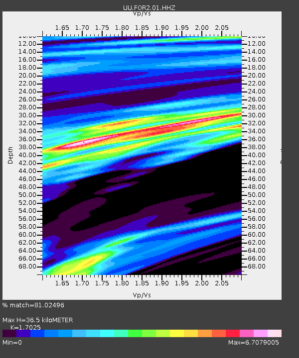
| Estimated Moho Depth: |
36.5 km |
| Estimated Crust Vp/Vs: |
1.70 |
| Assumed Crust Vp: |
6.276 km/s |
| Estimated Crust Vs: |
3.686 km/s |
| Estimated Crust Poisson's Ratio: |
0.24 |
|
| Radial Match: |
81.02496 % |
| Radial Bump: |
400 |
| Transverse Match: |
64.91923 % |
| Transverse Bump: |
379 |
| SOD ConfigId: |
25131211 |
| Insert Time: |
2021-07-07 05:52:13.442 +0000 |
| GWidth: |
2.5 |
| Max Bumps: |
400 |
| Tol: |
0.001 |
|

Signal To Noise
| Channel | StoN | STA | LTA |
| UU:FOR2:01:HHZ:20210623T05:52:22.964975Z | 0.9911196 | 4.8764073E-9 | 4.9200994E-9 |
| UU:FOR2:01:HHN:20210623T05:52:22.964975Z | 2.7090716 | 4.1572672E-8 | 1.5345726E-8 |
| UU:FOR2:01:HHE:20210623T05:52:22.964975Z | 0.9291235 | 1.8224982E-8 | 1.9615243E-8 |
| Arrivals |
| Ps | 4.2 SECOND |
| PpPs | 15 SECOND |
| PsPs/PpSs | 20 SECOND |


