You are here: Home > Network List > US - United States National Seismic Network Stations List
> Station MSO Missoula, Montana, USA > Earthquake Result Viewer
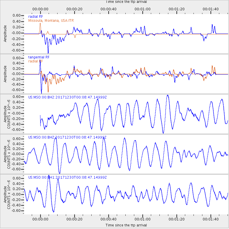
MSO Missoula, Montana, USA - Earthquake Result Viewer
*The percent match for this event was below the threshold and hence no stack was calculated.
| Earthquake location: |
New Britain Region, P.N.G. |
| Earthquake latitude/longitude: |
-5.4/150.8 |
| Earthquake time(UTC): |
2017/12/29 (363) 23:55:54 GMT |
| Earthquake Depth: |
90 km |
| Earthquake Magnitude: |
5.7 Mww |
| Earthquake Catalog/Contributor: |
NEIC PDE/us |
|
| Network: |
US United States National Seismic Network |
| Station: |
MSO Missoula, Montana, USA |
| Lat/Lon: |
46.83 N/113.94 W |
| Elevation: |
1264 m |
|
| Distance: |
97.5 deg |
| Az: |
43.605 deg |
| Baz: |
270.064 deg |
| Ray Param: |
$rayparam |
*The percent match for this event was below the threshold and hence was not used in the summary stack. |
|
| Radial Match: |
56.108273 % |
| Radial Bump: |
400 |
| Transverse Match: |
77.98793 % |
| Transverse Bump: |
400 |
| SOD ConfigId: |
2528331 |
| Insert Time: |
2018-01-12 23:57:39.898 +0000 |
| GWidth: |
2.5 |
| Max Bumps: |
400 |
| Tol: |
0.001 |
|
Signal To Noise
| Channel | StoN | STA | LTA |
| US:MSO:00:BHZ:20171230T00:08:47.14999Z | 0.7117234 | 2.618939E-7 | 3.679714E-7 |
| US:MSO:00:BH1:20171230T00:08:47.14999Z | 1.4399571 | 3.2831062E-7 | 2.2800029E-7 |
| US:MSO:00:BH2:20171230T00:08:47.14999Z | 1.9420887 | 4.033302E-7 | 2.0767857E-7 |
| Arrivals |
| Ps | |
| PpPs | |
| PsPs/PpSs | |


