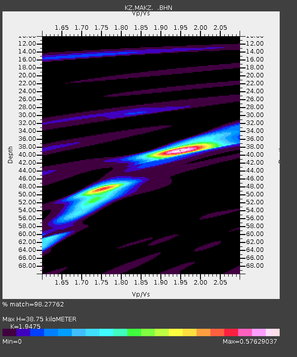
MAKZ Makanchi, Kazakstan - Earthquake Result Viewer

Earthquake location: New Britain Region, P.N.G.
Earthquake latitude/longitude: -5.2/150.9
Earthquake time(UTC): 1999/05/10 (130) 20:33:02 GMT
Earthquake Depth: 138 km
Earthquake Magnitude: 6.5 MB, 6.8 MS, 7.1 MW, 6.5 MB
Earthquake Catalog/Contributor: WHDF/NEIC
Network: KZ Kazakhstan Network
Station: MAKZ Makanchi, Kazakstan
Lat/Lon: 46.81 N/81.98 E
Elevation: 600 m
Distance: 79.6 deg
Az: 319.334 deg
Baz: 109.107 deg
Ray Param: 0.048555788
Estimated Moho Depth: 38.75 km
Estimated Crust Vp/Vs: 1.95
Assumed Crust Vp: 6.571 km/s
Estimated Crust Vs: 3.374 km/s
Estimated Crust Poisson's Ratio: 0.32
Radial Match: 98.27762 %
Radial Bump: 298
Transverse Match: 94.30842 %
Transverse Bump: 400
SOD ConfigId: 4480
Insert Time: 2010-03-09 09:37:59.187 +0000
GWidth: 2.5
Max Bumps: 400
Tol: 0.001

Signal To Noise

ChannelStoNSTALTA
KZ:MAKZ: :BHN:19990510T20:44:22.660007Z25.2055243.5342246E-61.4021627E-7
KZ:MAKZ: :BHE:19990510T20:44:22.660007Z11.519313.200711E-72.7785614E-8
KZ:MAKZ: :BHZ:19990510T20:44:22.660007Z32.1789327.305022E-72.2701258E-8
Arrivals
Ps5.7 SECOND
PpPs17 SECOND
PsPs/PpSs23 SECOND