You are here: Home > Network List > AV - Alaska Volcano Observatory Stations List
> Station AMKA Regional Station, Amchitka Island, Alaska > Earthquake Result Viewer
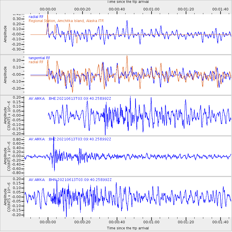
AMKA Regional Station, Amchitka Island, Alaska - Earthquake Result Viewer
*The percent match for this event was below the threshold and hence no stack was calculated.
| Earthquake location: |
Guatemala |
| Earthquake latitude/longitude: |
14.0/-91.5 |
| Earthquake time(UTC): |
2021/06/13 (164) 02:58:15 GMT |
| Earthquake Depth: |
63 km |
| Earthquake Magnitude: |
5.5 mww |
| Earthquake Catalog/Contributor: |
NEIC PDE/us |
|
| Network: |
AV Alaska Volcano Observatory |
| Station: |
AMKA Regional Station, Amchitka Island, Alaska |
| Lat/Lon: |
51.38 N/179.30 E |
| Elevation: |
116 m |
|
| Distance: |
78.7 deg |
| Az: |
320.277 deg |
| Baz: |
81.727 deg |
| Ray Param: |
$rayparam |
*The percent match for this event was below the threshold and hence was not used in the summary stack. |
|
| Radial Match: |
53.716045 % |
| Radial Bump: |
400 |
| Transverse Match: |
49.08709 % |
| Transverse Bump: |
400 |
| SOD ConfigId: |
25131211 |
| Insert Time: |
2021-07-09 23:23:03.514 +0000 |
| GWidth: |
2.5 |
| Max Bumps: |
400 |
| Tol: |
0.001 |
|
Signal To Noise
| Channel | StoN | STA | LTA |
| AV:AMKA: :BHZ:20210613T03:09:40.258992Z | 5.745915 | 2.6335388E-7 | 4.5833236E-8 |
| AV:AMKA: :BHN:20210613T03:09:40.258992Z | 0.85400665 | 4.055878E-8 | 4.749235E-8 |
| AV:AMKA: :BHE:20210613T03:09:40.258992Z | 0.9841697 | 5.940707E-8 | 6.036263E-8 |
| Arrivals |
| Ps | |
| PpPs | |
| PsPs/PpSs | |


