You are here: Home > Network List > IU - Global Seismograph Network (GSN - IRIS/USGS) Stations List
> Station PMG Port Moresby, New Guinea > Earthquake Result Viewer
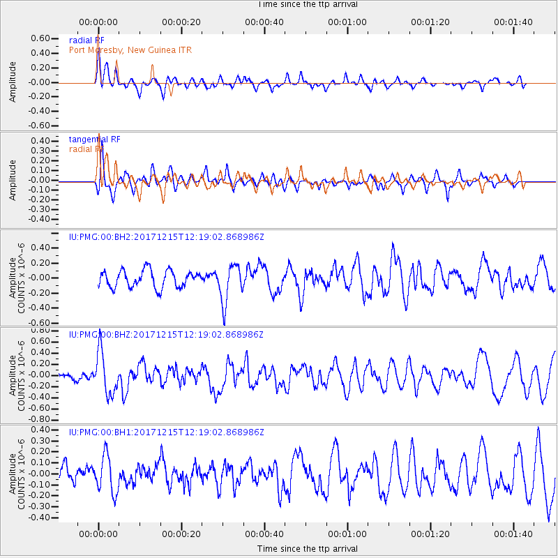
PMG Port Moresby, New Guinea - Earthquake Result Viewer
*The percent match for this event was below the threshold and hence no stack was calculated.
| Earthquake location: |
Tonga Islands |
| Earthquake latitude/longitude: |
-21.9/-174.4 |
| Earthquake time(UTC): |
2017/12/15 (349) 12:12:07 GMT |
| Earthquake Depth: |
10 km |
| Earthquake Magnitude: |
5.3 Mww |
| Earthquake Catalog/Contributor: |
NEIC PDE/us |
|
| Network: |
IU Global Seismograph Network (GSN - IRIS/USGS) |
| Station: |
PMG Port Moresby, New Guinea |
| Lat/Lon: |
9.40 S/147.16 E |
| Elevation: |
90 m |
|
| Distance: |
38.9 deg |
| Az: |
282.449 deg |
| Baz: |
113.181 deg |
| Ray Param: |
$rayparam |
*The percent match for this event was below the threshold and hence was not used in the summary stack. |
|
| Radial Match: |
62.186867 % |
| Radial Bump: |
400 |
| Transverse Match: |
64.71364 % |
| Transverse Bump: |
391 |
| SOD ConfigId: |
2528331 |
| Insert Time: |
2018-01-14 07:40:15.790 +0000 |
| GWidth: |
2.5 |
| Max Bumps: |
400 |
| Tol: |
0.001 |
|
Signal To Noise
| Channel | StoN | STA | LTA |
| IU:PMG:00:BHZ:20171215T12:19:02.868986Z | 3.5857153 | 3.8974898E-7 | 1.08694906E-7 |
| IU:PMG:00:BH1:20171215T12:19:02.868986Z | 1.5497113 | 1.7380084E-7 | 1.1215046E-7 |
| IU:PMG:00:BH2:20171215T12:19:02.868986Z | 2.3240843 | 2.6246445E-7 | 1.1293242E-7 |
| Arrivals |
| Ps | |
| PpPs | |
| PsPs/PpSs | |


