You are here: Home > Network List > CI - Caltech Regional Seismic Network Stations List
> Station SMM Simmler, CA, USA > Earthquake Result Viewer
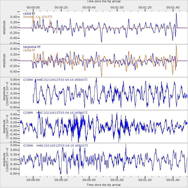
SMM Simmler, CA, USA - Earthquake Result Viewer
*The percent match for this event was below the threshold and hence no stack was calculated.
| Earthquake location: |
Guatemala |
| Earthquake latitude/longitude: |
14.0/-91.5 |
| Earthquake time(UTC): |
2021/06/13 (164) 02:58:15 GMT |
| Earthquake Depth: |
63 km |
| Earthquake Magnitude: |
5.5 mww |
| Earthquake Catalog/Contributor: |
NEIC PDE/us |
|
| Network: |
CI Caltech Regional Seismic Network |
| Station: |
SMM Simmler, CA, USA |
| Lat/Lon: |
35.31 N/120.00 W |
| Elevation: |
599 m |
|
| Distance: |
33.3 deg |
| Az: |
314.595 deg |
| Baz: |
122.328 deg |
| Ray Param: |
$rayparam |
*The percent match for this event was below the threshold and hence was not used in the summary stack. |
|
| Radial Match: |
55.668213 % |
| Radial Bump: |
400 |
| Transverse Match: |
57.985825 % |
| Transverse Bump: |
400 |
| SOD ConfigId: |
25131211 |
| Insert Time: |
2021-07-09 23:26:44.316 +0000 |
| GWidth: |
2.5 |
| Max Bumps: |
400 |
| Tol: |
0.001 |
|
Signal To Noise
| Channel | StoN | STA | LTA |
| CI:SMM: :HHZ:20210613T03:04:16.968007Z | 1.9550873 | 3.6006887E-7 | 1.8417022E-7 |
| CI:SMM: :HHN:20210613T03:04:16.968007Z | 1.079938 | 2.6524927E-7 | 2.4561524E-7 |
| CI:SMM: :HHE:20210613T03:04:16.968007Z | 0.6413635 | 2.4626556E-7 | 3.8397192E-7 |
| Arrivals |
| Ps | |
| PpPs | |
| PsPs/PpSs | |


