You are here: Home > Network List > AZ - ANZA Regional Network Stations List
> Station SMER AZ.SMER > Earthquake Result Viewer
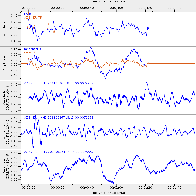
SMER AZ.SMER - Earthquake Result Viewer
*The percent match for this event was below the threshold and hence no stack was calculated.
| Earthquake location: |
Northern Mid-Atlantic Ridge |
| Earthquake latitude/longitude: |
11.8/-44.2 |
| Earthquake time(UTC): |
2021/06/26 (177) 18:01:22 GMT |
| Earthquake Depth: |
5.7 km |
| Earthquake Magnitude: |
5.6 mww |
| Earthquake Catalog/Contributor: |
NEIC PDE/us |
|
| Network: |
AZ ANZA Regional Network |
| Station: |
SMER AZ.SMER |
| Lat/Lon: |
33.46 N/117.17 W |
| Elevation: |
355 m |
|
| Distance: |
69.4 deg |
| Az: |
301.383 deg |
| Baz: |
89.248 deg |
| Ray Param: |
$rayparam |
*The percent match for this event was below the threshold and hence was not used in the summary stack. |
|
| Radial Match: |
39.92692 % |
| Radial Bump: |
400 |
| Transverse Match: |
40.136368 % |
| Transverse Bump: |
400 |
| SOD ConfigId: |
25131211 |
| Insert Time: |
2021-07-10 18:07:06.279 +0000 |
| GWidth: |
2.5 |
| Max Bumps: |
400 |
| Tol: |
0.001 |
|
Signal To Noise
| Channel | StoN | STA | LTA |
| AZ:SMER: :HHZ:20210626T18:12:00.007995Z | 4.0500774 | 3.435662E-7 | 8.482954E-8 |
| AZ:SMER: :HHN:20210626T18:12:00.007995Z | 0.8509789 | 1.7536608E-7 | 2.0607571E-7 |
| AZ:SMER: :HHE:20210626T18:12:00.007995Z | 1.3050233 | 1.3757108E-7 | 1.0541657E-7 |
| Arrivals |
| Ps | |
| PpPs | |
| PsPs/PpSs | |


