You are here: Home > Network List > CI - Caltech Regional Seismic Network Stations List
> Station MPM Manuel Prospect Mine, California, USA > Earthquake Result Viewer
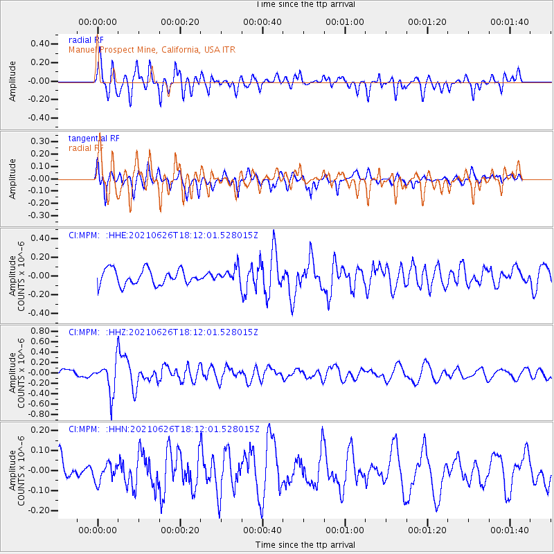
MPM Manuel Prospect Mine, California, USA - Earthquake Result Viewer
*The percent match for this event was below the threshold and hence no stack was calculated.
| Earthquake location: |
Northern Mid-Atlantic Ridge |
| Earthquake latitude/longitude: |
11.8/-44.2 |
| Earthquake time(UTC): |
2021/06/26 (177) 18:01:22 GMT |
| Earthquake Depth: |
5.7 km |
| Earthquake Magnitude: |
5.6 mww |
| Earthquake Catalog/Contributor: |
NEIC PDE/us |
|
| Network: |
CI Caltech Regional Seismic Network |
| Station: |
MPM Manuel Prospect Mine, California, USA |
| Lat/Lon: |
36.06 N/117.49 W |
| Elevation: |
185 m |
|
| Distance: |
69.7 deg |
| Az: |
304.153 deg |
| Baz: |
90.035 deg |
| Ray Param: |
$rayparam |
*The percent match for this event was below the threshold and hence was not used in the summary stack. |
|
| Radial Match: |
72.011604 % |
| Radial Bump: |
400 |
| Transverse Match: |
57.79045 % |
| Transverse Bump: |
400 |
| SOD ConfigId: |
25131211 |
| Insert Time: |
2021-07-10 18:10:53.124 +0000 |
| GWidth: |
2.5 |
| Max Bumps: |
400 |
| Tol: |
0.001 |
|
Signal To Noise
| Channel | StoN | STA | LTA |
| CI:MPM: :HHZ:20210626T18:12:01.528015Z | 3.9141366 | 3.1803282E-7 | 8.125236E-8 |
| CI:MPM: :HHN:20210626T18:12:01.528015Z | 0.8302078 | 4.66651E-8 | 5.620894E-8 |
| CI:MPM: :HHE:20210626T18:12:01.528015Z | 0.9840972 | 7.953908E-8 | 8.0824414E-8 |
| Arrivals |
| Ps | |
| PpPs | |
| PsPs/PpSs | |


