You are here: Home > Network List > CI - Caltech Regional Seismic Network Stations List
> Station MPP McPhearson Peak > Earthquake Result Viewer
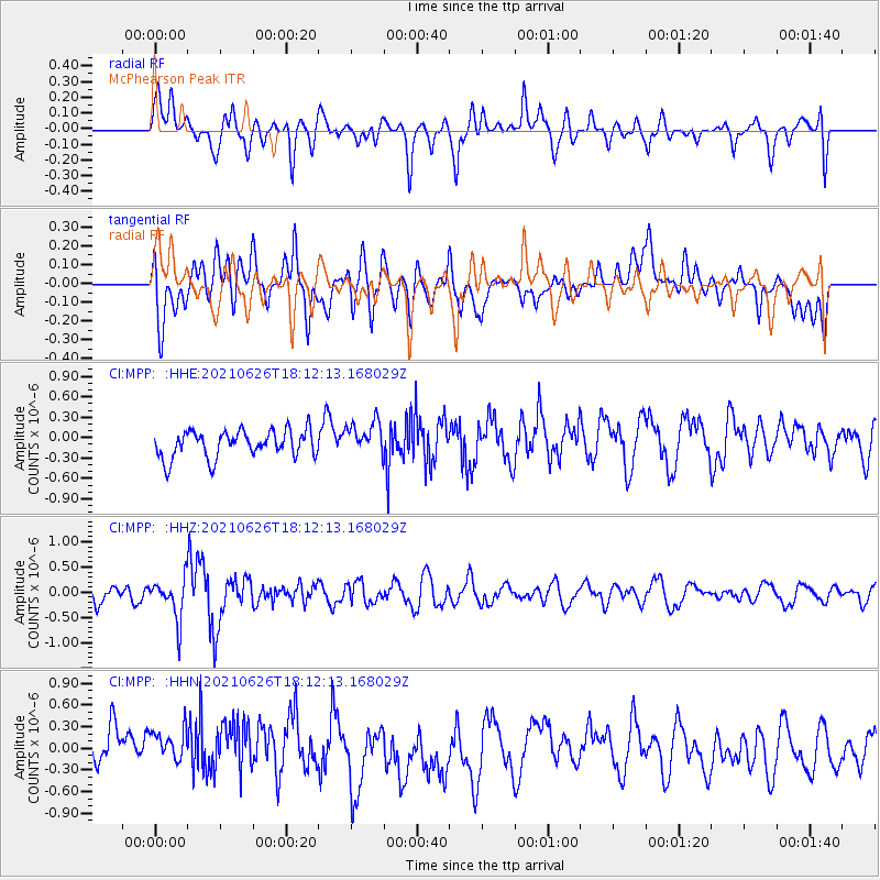
MPP McPhearson Peak - Earthquake Result Viewer
*The percent match for this event was below the threshold and hence no stack was calculated.
| Earthquake location: |
Northern Mid-Atlantic Ridge |
| Earthquake latitude/longitude: |
11.8/-44.2 |
| Earthquake time(UTC): |
2021/06/26 (177) 18:01:22 GMT |
| Earthquake Depth: |
5.7 km |
| Earthquake Magnitude: |
5.6 mww |
| Earthquake Catalog/Contributor: |
NEIC PDE/us |
|
| Network: |
CI Caltech Regional Seismic Network |
| Station: |
MPP McPhearson Peak |
| Lat/Lon: |
34.89 N/119.81 W |
| Elevation: |
1739 m |
|
| Distance: |
71.6 deg |
| Az: |
302.946 deg |
| Baz: |
88.291 deg |
| Ray Param: |
$rayparam |
*The percent match for this event was below the threshold and hence was not used in the summary stack. |
|
| Radial Match: |
68.83609 % |
| Radial Bump: |
400 |
| Transverse Match: |
46.784378 % |
| Transverse Bump: |
400 |
| SOD ConfigId: |
25131211 |
| Insert Time: |
2021-07-10 18:10:54.804 +0000 |
| GWidth: |
2.5 |
| Max Bumps: |
400 |
| Tol: |
0.001 |
|
Signal To Noise
| Channel | StoN | STA | LTA |
| CI:MPP: :HHZ:20210626T18:12:13.168029Z | 2.28961 | 4.02668E-7 | 1.7586753E-7 |
| CI:MPP: :HHN:20210626T18:12:13.168029Z | 1.0770333 | 3.419217E-7 | 3.1746623E-7 |
| CI:MPP: :HHE:20210626T18:12:13.168029Z | 1.2753097 | 2.528479E-7 | 1.9826393E-7 |
| Arrivals |
| Ps | |
| PpPs | |
| PsPs/PpSs | |


