You are here: Home > Network List > CN - Canadian National Seismograph Network Stations List
> Station INK INUVIK, NT > Earthquake Result Viewer
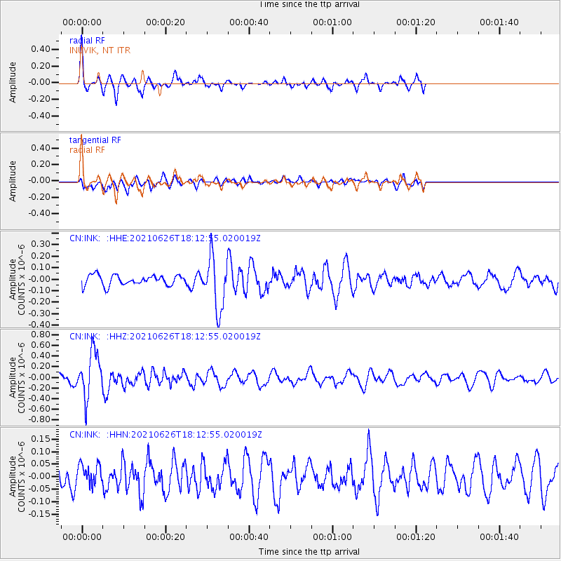
INK INUVIK, NT - Earthquake Result Viewer
*The percent match for this event was below the threshold and hence no stack was calculated.
| Earthquake location: |
Northern Mid-Atlantic Ridge |
| Earthquake latitude/longitude: |
11.8/-44.2 |
| Earthquake time(UTC): |
2021/06/26 (177) 18:01:22 GMT |
| Earthquake Depth: |
5.7 km |
| Earthquake Magnitude: |
5.6 mww |
| Earthquake Catalog/Contributor: |
NEIC PDE/us |
|
| Network: |
CN Canadian National Seismograph Network |
| Station: |
INK INUVIK, NT |
| Lat/Lon: |
68.31 N/133.53 W |
| Elevation: |
44 m |
|
| Distance: |
78.9 deg |
| Az: |
337.736 deg |
| Baz: |
86.227 deg |
| Ray Param: |
$rayparam |
*The percent match for this event was below the threshold and hence was not used in the summary stack. |
|
| Radial Match: |
76.997215 % |
| Radial Bump: |
307 |
| Transverse Match: |
54.586243 % |
| Transverse Bump: |
400 |
| SOD ConfigId: |
25131211 |
| Insert Time: |
2021-07-10 18:12:38.542 +0000 |
| GWidth: |
2.5 |
| Max Bumps: |
400 |
| Tol: |
0.001 |
|
Signal To Noise
| Channel | StoN | STA | LTA |
| CN:INK: :HHZ:20210626T18:12:55.020019Z | 6.1285005 | 4.307426E-7 | 7.0285154E-8 |
| CN:INK: :HHN:20210626T18:12:55.020019Z | 0.93285114 | 4.1695465E-8 | 4.4696804E-8 |
| CN:INK: :HHE:20210626T18:12:55.020019Z | 5.193988 | 2.3065142E-7 | 4.440739E-8 |
| Arrivals |
| Ps | |
| PpPs | |
| PsPs/PpSs | |


