You are here: Home > Network List > XW97 - Tien Shan Continental Dynamics Stations List
> Station PDG XW.PDG > Earthquake Result Viewer
PDG XW.PDG - Earthquake Result Viewer
| Earthquake location: |
Santa Cruz Islands |
| Earthquake latitude/longitude: |
-11.4/165.4 |
| Earthquake time(UTC): |
2000/01/05 (005) 07:40:40 GMT |
| Earthquake Depth: |
33 km |
| Earthquake Magnitude: |
5.7 MB, 6.0 MS, 6.2 MW, 6.1 MW |
| Earthquake Catalog/Contributor: |
WHDF/NEIC |
|
| Network: |
XW Tien Shan Continental Dynamics |
| Station: |
PDG XW.PDG |
| Lat/Lon: |
43.33 N/79.49 E |
| Elevation: |
1286 m |
|
| Distance: |
94.7 deg |
| Az: |
313.083 deg |
| Baz: |
101.049 deg |
| Ray Param: |
0.0409529 |
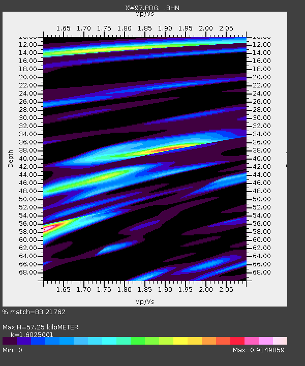
| Estimated Moho Depth: |
57.25 km |
| Estimated Crust Vp/Vs: |
1.60 |
| Assumed Crust Vp: |
6.306 km/s |
| Estimated Crust Vs: |
3.935 km/s |
| Estimated Crust Poisson's Ratio: |
0.18 |
|
| Radial Match: |
83.21762 % |
| Radial Bump: |
400 |
| Transverse Match: |
66.15735 % |
| Transverse Bump: |
400 |
| SOD ConfigId: |
3744 |
| Insert Time: |
2010-02-26 15:42:22.735 +0000 |
| GWidth: |
2.5 |
| Max Bumps: |
400 |
| Tol: |
0.001 |
|

Signal To Noise
| Channel | StoN | STA | LTA |
| XW:PDG: :BHN:20000105T07:53:27.399006Z | 0.61100745 | 7.7426144E-8 | 1.2671882E-7 |
| XW:PDG: :BHE:20000105T07:53:27.399006Z | 0.67632496 | 6.606429E-8 | 9.768128E-8 |
| XW:PDG: :BHZ:20000105T07:53:27.399006Z | 1.7312392 | 1.8796841E-7 | 1.0857449E-7 |
| Arrivals |
| Ps | 5.6 SECOND |
| PpPs | 23 SECOND |
| PsPs/PpSs | 29 SECOND |


