You are here: Home > Network List > CN - Canadian National Seismograph Network Stations List
> Station TBO Thunder Bay, ON, CA > Earthquake Result Viewer
TBO Thunder Bay, ON, CA - Earthquake Result Viewer
| Earthquake location: |
Northern Mid-Atlantic Ridge |
| Earthquake latitude/longitude: |
11.8/-44.2 |
| Earthquake time(UTC): |
2021/06/26 (177) 18:01:22 GMT |
| Earthquake Depth: |
5.7 km |
| Earthquake Magnitude: |
5.6 mww |
| Earthquake Catalog/Contributor: |
NEIC PDE/us |
|
| Network: |
CN Canadian National Seismograph Network |
| Station: |
TBO Thunder Bay, ON, CA |
| Lat/Lon: |
48.65 N/89.41 W |
| Elevation: |
475 m |
|
| Distance: |
52.4 deg |
| Az: |
323.588 deg |
| Baz: |
118.79 deg |
| Ray Param: |
0.06676064 |
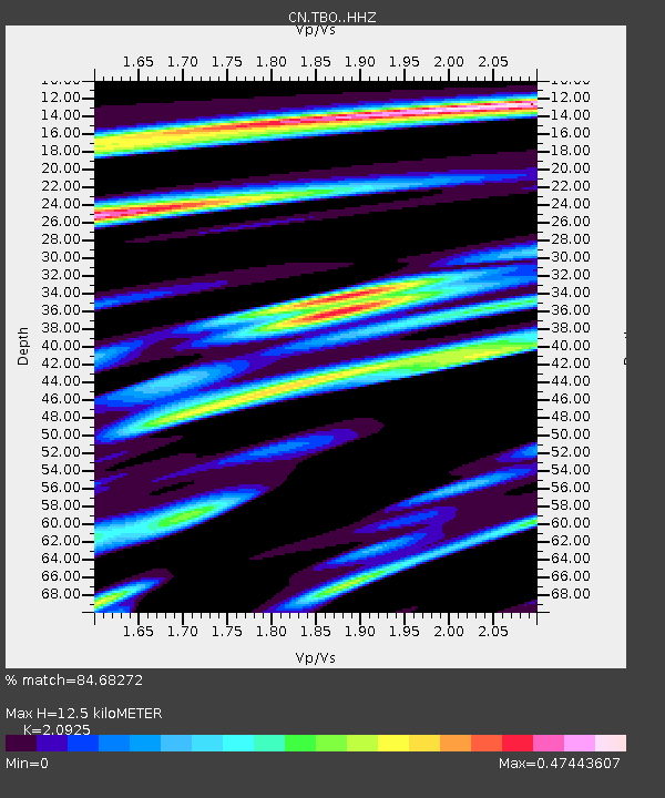
| Estimated Moho Depth: |
12.5 km |
| Estimated Crust Vp/Vs: |
2.09 |
| Assumed Crust Vp: |
6.467 km/s |
| Estimated Crust Vs: |
3.09 km/s |
| Estimated Crust Poisson's Ratio: |
0.35 |
|
| Radial Match: |
84.68272 % |
| Radial Bump: |
315 |
| Transverse Match: |
50.464306 % |
| Transverse Bump: |
400 |
| SOD ConfigId: |
25131211 |
| Insert Time: |
2021-07-10 18:13:43.061 +0000 |
| GWidth: |
2.5 |
| Max Bumps: |
400 |
| Tol: |
0.001 |
|

Signal To Noise
| Channel | StoN | STA | LTA |
| CN:TBO: :HHZ:20210626T18:10:04.71997Z | 6.9049115 | 5.587935E-7 | 8.092696E-8 |
| CN:TBO: :HHN:20210626T18:10:04.71997Z | 3.760847 | 1.6474132E-7 | 4.3804313E-8 |
| CN:TBO: :HHE:20210626T18:10:04.71997Z | 5.2265325 | 2.4969344E-7 | 4.7774208E-8 |
| Arrivals |
| Ps | 2.2 SECOND |
| PpPs | 5.7 SECOND |
| PsPs/PpSs | 7.9 SECOND |


