You are here: Home > Network List > IW - Intermountain West Stations List
> Station DLMT Dillon, Montana, USA > Earthquake Result Viewer
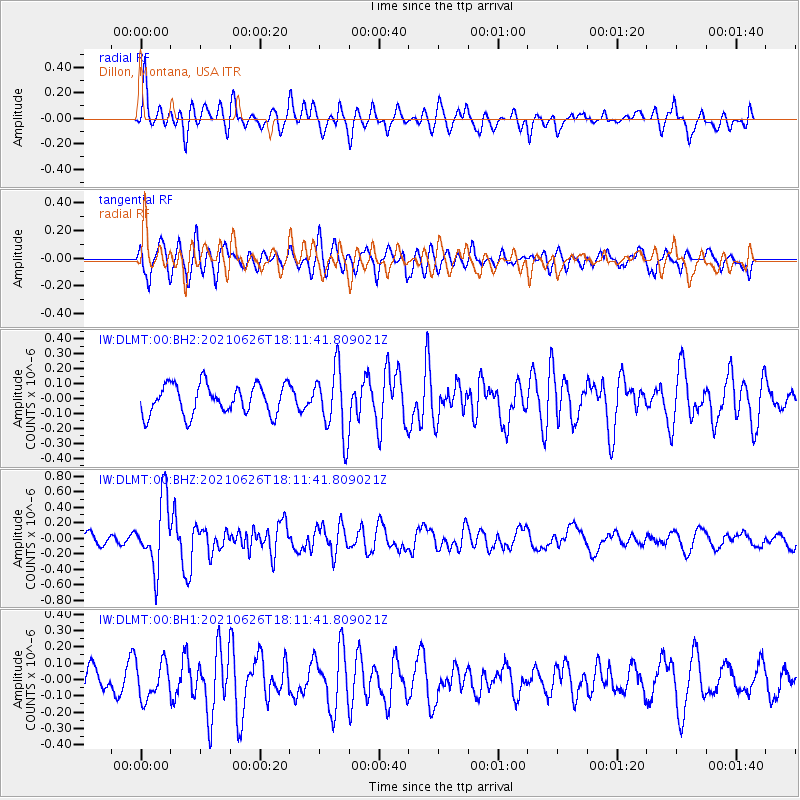
DLMT Dillon, Montana, USA - Earthquake Result Viewer
*The percent match for this event was below the threshold and hence no stack was calculated.
| Earthquake location: |
Northern Mid-Atlantic Ridge |
| Earthquake latitude/longitude: |
11.8/-44.2 |
| Earthquake time(UTC): |
2021/06/26 (177) 18:01:22 GMT |
| Earthquake Depth: |
5.7 km |
| Earthquake Magnitude: |
5.6 mww |
| Earthquake Catalog/Contributor: |
NEIC PDE/us |
|
| Network: |
IW Intermountain West |
| Station: |
DLMT Dillon, Montana, USA |
| Lat/Lon: |
45.36 N/112.60 W |
| Elevation: |
1569 m |
|
| Distance: |
66.5 deg |
| Az: |
314.393 deg |
| Baz: |
97.055 deg |
| Ray Param: |
$rayparam |
*The percent match for this event was below the threshold and hence was not used in the summary stack. |
|
| Radial Match: |
68.831924 % |
| Radial Bump: |
400 |
| Transverse Match: |
73.408806 % |
| Transverse Bump: |
400 |
| SOD ConfigId: |
25131211 |
| Insert Time: |
2021-07-10 18:17:29.375 +0000 |
| GWidth: |
2.5 |
| Max Bumps: |
400 |
| Tol: |
0.001 |
|
Signal To Noise
| Channel | StoN | STA | LTA |
| IW:DLMT:00:BHZ:20210626T18:11:41.809021Z | 4.75641 | 4.3875394E-7 | 9.224477E-8 |
| IW:DLMT:00:BH1:20210626T18:11:41.809021Z | 1.3343866 | 1.0986139E-7 | 8.2331E-8 |
| IW:DLMT:00:BH2:20210626T18:11:41.809021Z | 2.2543752 | 2.2343617E-7 | 9.9112235E-8 |
| Arrivals |
| Ps | |
| PpPs | |
| PsPs/PpSs | |


