You are here: Home > Network List > UW - Pacific Northwest Regional Seismic Network Stations List
> Station HOOD Mt Hood Meadows, OR CREST BB SMO > Earthquake Result Viewer
HOOD Mt Hood Meadows, OR CREST BB SMO - Earthquake Result Viewer
*The percent match for this event was below the threshold and hence no stack was calculated.
| Earthquake location: |
Northern Mid-Atlantic Ridge |
| Earthquake latitude/longitude: |
11.8/-44.2 |
| Earthquake time(UTC): |
2021/06/26 (177) 18:01:22 GMT |
| Earthquake Depth: |
5.7 km |
| Earthquake Magnitude: |
5.6 mww |
| Earthquake Catalog/Contributor: |
NEIC PDE/us |
|
| Network: |
UW Pacific Northwest Regional Seismic Network |
| Station: |
HOOD Mt Hood Meadows, OR CREST BB SMO |
| Lat/Lon: |
45.32 N/121.65 W |
| Elevation: |
1520 m |
|
| Distance: |
72.9 deg |
| Az: |
313.904 deg |
| Baz: |
90.458 deg |
| Ray Param: |
$rayparam |
*The percent match for this event was below the threshold and hence was not used in the summary stack. |
|
| Radial Match: |
49.6491 % |
| Radial Bump: |
400 |
| Transverse Match: |
57.569527 % |
| Transverse Bump: |
400 |
| SOD ConfigId: |
25131211 |
| Insert Time: |
2021-07-10 18:33:40.833 +0000 |
| GWidth: |
2.5 |
| Max Bumps: |
400 |
| Tol: |
0.001 |
|
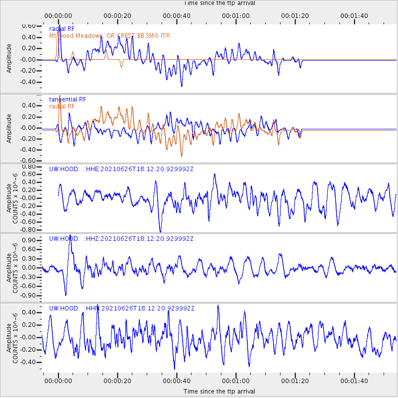
Signal To Noise
| Channel | StoN | STA | LTA |
| UW:HOOD: :HHZ:20210626T18:12:20.929992Z | 6.461786 | 4.9227594E-7 | 7.618265E-8 |
| UW:HOOD: :HHN:20210626T18:12:20.929992Z | 1.573791 | 1.6264971E-7 | 1.0334899E-7 |
| UW:HOOD: :HHE:20210626T18:12:20.929992Z | 2.8470972 | 3.7936763E-7 | 1.3324717E-7 |
| Arrivals |
| Ps | |
| PpPs | |
| PsPs/PpSs | |


