You are here: Home > Network List > KZ - Kazakhstan Network Stations List
> Station MKAR Makanchi array,MK31, Kazakhstan > Earthquake Result Viewer
MKAR Makanchi array,MK31, Kazakhstan - Earthquake Result Viewer
| Earthquake location: |
Bismarck Sea |
| Earthquake latitude/longitude: |
-3.3/146.8 |
| Earthquake time(UTC): |
2007/06/07 (158) 00:40:38 GMT |
| Earthquake Depth: |
4.7 km |
| Earthquake Magnitude: |
5.8 MB, 6.2 MS, 6.2 MW, 6.2 MW |
| Earthquake Catalog/Contributor: |
WHDF/NEIC |
|
| Network: |
KZ Kazakhstan Network |
| Station: |
MKAR Makanchi array,MK31, Kazakhstan |
| Lat/Lon: |
46.79 N/82.29 E |
| Elevation: |
615 m |
|
| Distance: |
75.3 deg |
| Az: |
320.135 deg |
| Baz: |
111.348 deg |
| Ray Param: |
0.051777013 |
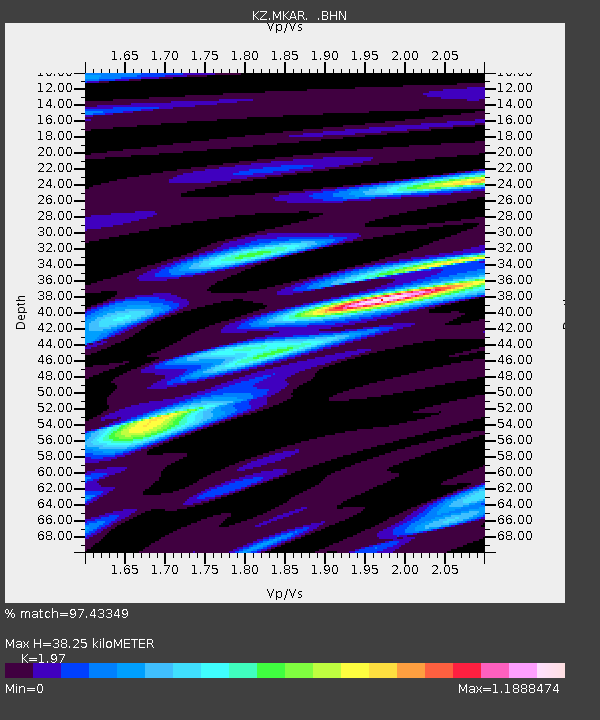
| Estimated Moho Depth: |
38.25 km |
| Estimated Crust Vp/Vs: |
1.97 |
| Assumed Crust Vp: |
6.688 km/s |
| Estimated Crust Vs: |
3.395 km/s |
| Estimated Crust Poisson's Ratio: |
0.33 |
|
| Radial Match: |
97.43349 % |
| Radial Bump: |
400 |
| Transverse Match: |
90.4932 % |
| Transverse Bump: |
400 |
| SOD ConfigId: |
2564 |
| Insert Time: |
2010-03-09 09:44:19.711 +0000 |
| GWidth: |
2.5 |
| Max Bumps: |
400 |
| Tol: |
0.001 |
|

Signal To Noise
| Channel | StoN | STA | LTA |
| KZ:MKAR: :BHN:20070607T00:51:50.848018Z | 3.492259 | 1.3472078E-7 | 3.857697E-8 |
| KZ:MKAR: :BHE:20070607T00:51:50.848018Z | 4.408374 | 2.0669852E-7 | 4.68877E-8 |
| KZ:MKAR: :BHZ:20070607T00:51:50.848018Z | 11.648991 | 6.982998E-7 | 5.9945094E-8 |
| Arrivals |
| Ps | 5.7 SECOND |
| PpPs | 16 SECOND |
| PsPs/PpSs | 22 SECOND |


