You are here: Home > Network List > WY - Yellowstone Wyoming Seismic Network Stations List
> Station YPP Pitchstone Plateau, YNP, WY, USA > Earthquake Result Viewer
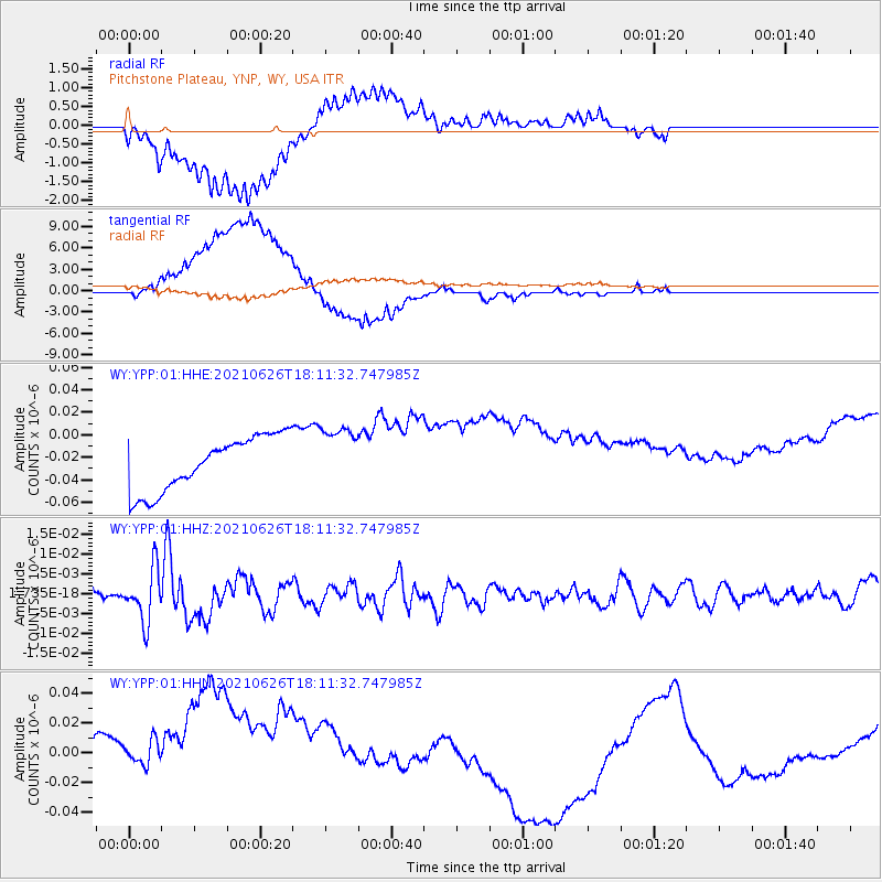
YPP Pitchstone Plateau, YNP, WY, USA - Earthquake Result Viewer
*The percent match for this event was below the threshold and hence no stack was calculated.
| Earthquake location: |
Northern Mid-Atlantic Ridge |
| Earthquake latitude/longitude: |
11.8/-44.2 |
| Earthquake time(UTC): |
2021/06/26 (177) 18:01:22 GMT |
| Earthquake Depth: |
5.7 km |
| Earthquake Magnitude: |
5.6 mww |
| Earthquake Catalog/Contributor: |
NEIC PDE/us |
|
| Network: |
WY Yellowstone Wyoming Seismic Network |
| Station: |
YPP Pitchstone Plateau, YNP, WY, USA |
| Lat/Lon: |
44.27 N/110.80 W |
| Elevation: |
2707 m |
|
| Distance: |
65.1 deg |
| Az: |
313.389 deg |
| Baz: |
97.903 deg |
| Ray Param: |
$rayparam |
*The percent match for this event was below the threshold and hence was not used in the summary stack. |
|
| Radial Match: |
30.527534 % |
| Radial Bump: |
400 |
| Transverse Match: |
48.26562 % |
| Transverse Bump: |
400 |
| SOD ConfigId: |
25131211 |
| Insert Time: |
2021-07-10 18:35:31.299 +0000 |
| GWidth: |
2.5 |
| Max Bumps: |
400 |
| Tol: |
0.001 |
|
Signal To Noise
| Channel | StoN | STA | LTA |
| WY:YPP:01:HHZ:20210626T18:11:32.747985Z | 3.671046 | 6.568495E-9 | 1.7892707E-9 |
| WY:YPP:01:HHN:20210626T18:11:32.747985Z | 1.038269 | 6.527173E-8 | 6.286591E-8 |
| WY:YPP:01:HHE:20210626T18:11:32.747985Z | 1.1393404 | 2.7384429E-8 | 2.4035335E-8 |
| Arrivals |
| Ps | |
| PpPs | |
| PsPs/PpSs | |


