You are here: Home > Network List > AK - Alaska Regional Network Stations List
> Station MDM Murphy Dome > Earthquake Result Viewer
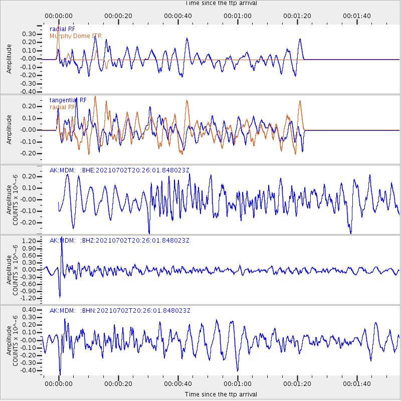
MDM Murphy Dome - Earthquake Result Viewer
*The percent match for this event was below the threshold and hence no stack was calculated.
| Earthquake location: |
Fiji Islands Region |
| Earthquake latitude/longitude: |
-21.8/-179.4 |
| Earthquake time(UTC): |
2021/07/02 (183) 20:14:38 GMT |
| Earthquake Depth: |
606 km |
| Earthquake Magnitude: |
6.1 Mww |
| Earthquake Catalog/Contributor: |
NEIC PDE/us |
|
| Network: |
AK Alaska Regional Network |
| Station: |
MDM Murphy Dome |
| Lat/Lon: |
64.96 N/148.23 W |
| Elevation: |
634 m |
|
| Distance: |
89.8 deg |
| Az: |
12.712 deg |
| Baz: |
208.712 deg |
| Ray Param: |
$rayparam |
*The percent match for this event was below the threshold and hence was not used in the summary stack. |
|
| Radial Match: |
57.1083 % |
| Radial Bump: |
392 |
| Transverse Match: |
45.329247 % |
| Transverse Bump: |
400 |
| SOD ConfigId: |
25131211 |
| Insert Time: |
2021-07-16 20:17:35.547 +0000 |
| GWidth: |
2.5 |
| Max Bumps: |
400 |
| Tol: |
0.001 |
|
Signal To Noise
| Channel | StoN | STA | LTA |
| AK:MDM: :BHZ:20210702T20:26:01.848023Z | 4.7079577 | 4.4957642E-7 | 9.549287E-8 |
| AK:MDM: :BHN:20210702T20:26:01.848023Z | 2.0114648 | 1.7089477E-7 | 8.4960355E-8 |
| AK:MDM: :BHE:20210702T20:26:01.848023Z | 1.0626124 | 1.1113034E-7 | 1.045822E-7 |
| Arrivals |
| Ps | |
| PpPs | |
| PsPs/PpSs | |


