You are here: Home > Network List > AV - Alaska Volcano Observatory Stations List
> Station AMKA Regional Station, Amchitka Island, Alaska > Earthquake Result Viewer
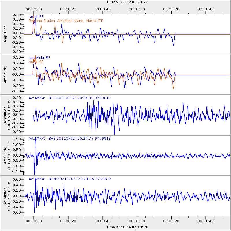
AMKA Regional Station, Amchitka Island, Alaska - Earthquake Result Viewer
*The percent match for this event was below the threshold and hence no stack was calculated.
| Earthquake location: |
Fiji Islands Region |
| Earthquake latitude/longitude: |
-21.8/-179.4 |
| Earthquake time(UTC): |
2021/07/02 (183) 20:14:38 GMT |
| Earthquake Depth: |
606 km |
| Earthquake Magnitude: |
6.1 Mww |
| Earthquake Catalog/Contributor: |
NEIC PDE/us |
|
| Network: |
AV Alaska Volcano Observatory |
| Station: |
AMKA Regional Station, Amchitka Island, Alaska |
| Lat/Lon: |
51.38 N/179.30 E |
| Elevation: |
116 m |
|
| Distance: |
72.9 deg |
| Az: |
359.124 deg |
| Baz: |
178.701 deg |
| Ray Param: |
$rayparam |
*The percent match for this event was below the threshold and hence was not used in the summary stack. |
|
| Radial Match: |
49.483868 % |
| Radial Bump: |
400 |
| Transverse Match: |
62.679398 % |
| Transverse Bump: |
400 |
| SOD ConfigId: |
25131211 |
| Insert Time: |
2021-07-16 20:19:41.719 +0000 |
| GWidth: |
2.5 |
| Max Bumps: |
400 |
| Tol: |
0.001 |
|
Signal To Noise
| Channel | StoN | STA | LTA |
| AV:AMKA: :BHZ:20210702T20:24:35.979981Z | 9.160916 | 6.1266826E-7 | 6.6878485E-8 |
| AV:AMKA: :BHN:20210702T20:24:35.979981Z | 4.0135803 | 2.2288341E-7 | 5.553232E-8 |
| AV:AMKA: :BHE:20210702T20:24:35.979981Z | 1.9786513 | 1.5723596E-7 | 7.946623E-8 |
| Arrivals |
| Ps | |
| PpPs | |
| PsPs/PpSs | |


