You are here: Home > Network List > KZ - Kazakhstan Network Stations List
> Station MKAR Makanchi array,MK31, Kazakhstan > Earthquake Result Viewer
MKAR Makanchi array,MK31, Kazakhstan - Earthquake Result Viewer
| Earthquake location: |
Taiwan |
| Earthquake latitude/longitude: |
23.6/121.5 |
| Earthquake time(UTC): |
2009/10/03 (276) 17:36:06 GMT |
| Earthquake Depth: |
28 km |
| Earthquake Magnitude: |
6.0 MB, 5.7 MS, 6.0 MW, 6.1 MW |
| Earthquake Catalog/Contributor: |
WHDF/NEIC |
|
| Network: |
KZ Kazakhstan Network |
| Station: |
MKAR Makanchi array,MK31, Kazakhstan |
| Lat/Lon: |
46.79 N/82.29 E |
| Elevation: |
615 m |
|
| Distance: |
38.9 deg |
| Az: |
316.301 deg |
| Baz: |
112.748 deg |
| Ray Param: |
0.07524316 |
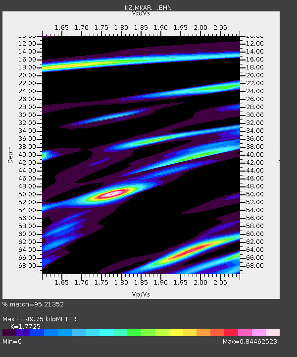
| Estimated Moho Depth: |
49.75 km |
| Estimated Crust Vp/Vs: |
1.77 |
| Assumed Crust Vp: |
6.688 km/s |
| Estimated Crust Vs: |
3.773 km/s |
| Estimated Crust Poisson's Ratio: |
0.27 |
|
| Radial Match: |
95.21352 % |
| Radial Bump: |
369 |
| Transverse Match: |
81.48093 % |
| Transverse Bump: |
400 |
| SOD ConfigId: |
2622 |
| Insert Time: |
2010-03-09 09:46:24.291 +0000 |
| GWidth: |
2.5 |
| Max Bumps: |
400 |
| Tol: |
0.001 |
|

Signal To Noise
| Channel | StoN | STA | LTA |
| KZ:MKAR: :BHN:20091003T17:42:58.648992Z | 33.54031 | 3.1448972E-6 | 9.3764704E-8 |
| KZ:MKAR: :BHE:20091003T17:42:58.648992Z | 6.565263 | 6.79482E-7 | 1.0349654E-7 |
| KZ:MKAR: :BHZ:20091003T17:42:58.648992Z | 19.817017 | 1.7344977E-6 | 8.752568E-8 |
| Arrivals |
| Ps | 6.2 SECOND |
| PpPs | 19 SECOND |
| PsPs/PpSs | 25 SECOND |


