You are here: Home > Network List > KZ - Kazakhstan Network Stations List
> Station MKAR Makanchi array,MK31, Kazakhstan > Earthquake Result Viewer
MKAR Makanchi array,MK31, Kazakhstan - Earthquake Result Viewer
| Earthquake location: |
Irian Jaya Region, Indonesia |
| Earthquake latitude/longitude: |
-0.8/134.1 |
| Earthquake time(UTC): |
2009/10/23 (296) 11:15:25 GMT |
| Earthquake Depth: |
15 km |
| Earthquake Magnitude: |
5.9 MB, 5.4 MS, 5.8 MW, 5.8 MW |
| Earthquake Catalog/Contributor: |
WHDF/NEIC |
|
| Network: |
KZ Kazakhstan Network |
| Station: |
MKAR Makanchi array,MK31, Kazakhstan |
| Lat/Lon: |
46.79 N/82.29 E |
| Elevation: |
615 m |
|
| Distance: |
65.6 deg |
| Az: |
323.598 deg |
| Baz: |
120.271 deg |
| Ray Param: |
0.058183964 |
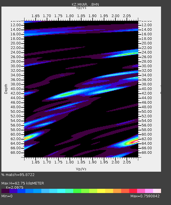
| Estimated Moho Depth: |
62.75 km |
| Estimated Crust Vp/Vs: |
2.10 |
| Assumed Crust Vp: |
6.688 km/s |
| Estimated Crust Vs: |
3.189 km/s |
| Estimated Crust Poisson's Ratio: |
0.35 |
|
| Radial Match: |
95.8722 % |
| Radial Bump: |
400 |
| Transverse Match: |
89.6697 % |
| Transverse Bump: |
400 |
| SOD ConfigId: |
2622 |
| Insert Time: |
2010-03-09 09:46:51.543 +0000 |
| GWidth: |
2.5 |
| Max Bumps: |
400 |
| Tol: |
0.001 |
|

Signal To Noise
| Channel | StoN | STA | LTA |
| KZ:MKAR: :BHN:20091023T11:25:37.125007Z | 64.22315 | 4.7116873E-6 | 7.3364305E-8 |
| KZ:MKAR: :BHE:20091023T11:25:37.125007Z | 13.566686 | 1.1354864E-6 | 8.369667E-8 |
| KZ:MKAR: :BHZ:20091023T11:25:37.125007Z | 41.649174 | 1.917916E-6 | 4.6049323E-8 |
| Arrivals |
| Ps | 11 SECOND |
| PpPs | 28 SECOND |
| PsPs/PpSs | 39 SECOND |


