You are here: Home > Network List > AZ - ANZA Regional Network Stations List
> Station SMER AZ.SMER > Earthquake Result Viewer
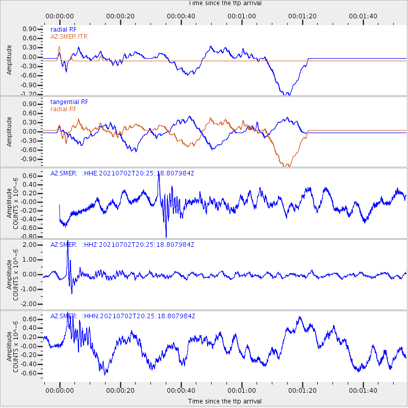
SMER AZ.SMER - Earthquake Result Viewer
*The percent match for this event was below the threshold and hence no stack was calculated.
| Earthquake location: |
Fiji Islands Region |
| Earthquake latitude/longitude: |
-21.8/-179.4 |
| Earthquake time(UTC): |
2021/07/02 (183) 20:14:38 GMT |
| Earthquake Depth: |
606 km |
| Earthquake Magnitude: |
6.1 Mww |
| Earthquake Catalog/Contributor: |
NEIC PDE/us |
|
| Network: |
AZ ANZA Regional Network |
| Station: |
SMER AZ.SMER |
| Lat/Lon: |
33.46 N/117.17 W |
| Elevation: |
355 m |
|
| Distance: |
80.8 deg |
| Az: |
48.507 deg |
| Baz: |
236.357 deg |
| Ray Param: |
$rayparam |
*The percent match for this event was below the threshold and hence was not used in the summary stack. |
|
| Radial Match: |
27.376537 % |
| Radial Bump: |
400 |
| Transverse Match: |
32.18241 % |
| Transverse Bump: |
400 |
| SOD ConfigId: |
25131211 |
| Insert Time: |
2021-07-16 20:21:57.717 +0000 |
| GWidth: |
2.5 |
| Max Bumps: |
400 |
| Tol: |
0.001 |
|
Signal To Noise
| Channel | StoN | STA | LTA |
| AZ:SMER: :HHZ:20210702T20:25:18.807984Z | 8.91702 | 6.777074E-7 | 7.6001555E-8 |
| AZ:SMER: :HHN:20210702T20:25:18.807984Z | 1.0345722 | 5.792559E-7 | 5.59899E-7 |
| AZ:SMER: :HHE:20210702T20:25:18.807984Z | 1.5114635 | 2.8183405E-7 | 1.8646435E-7 |
| Arrivals |
| Ps | |
| PpPs | |
| PsPs/PpSs | |


