You are here: Home > Network List > CI - Caltech Regional Seismic Network Stations List
> Station MPM Manuel Prospect Mine, California, USA > Earthquake Result Viewer
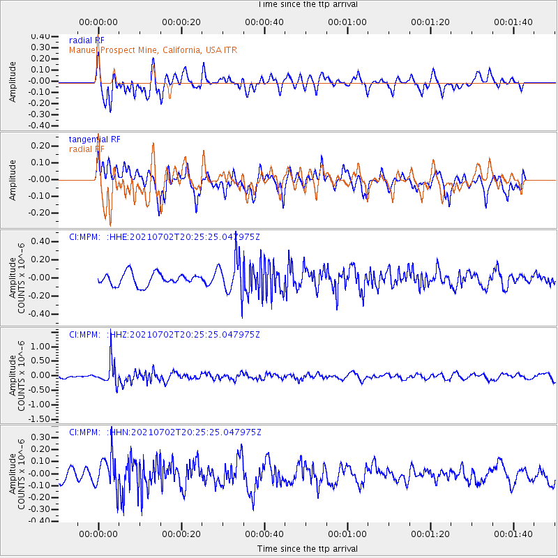
MPM Manuel Prospect Mine, California, USA - Earthquake Result Viewer
*The percent match for this event was below the threshold and hence no stack was calculated.
| Earthquake location: |
Fiji Islands Region |
| Earthquake latitude/longitude: |
-21.8/-179.4 |
| Earthquake time(UTC): |
2021/07/02 (183) 20:14:38 GMT |
| Earthquake Depth: |
606 km |
| Earthquake Magnitude: |
6.1 Mww |
| Earthquake Catalog/Contributor: |
NEIC PDE/us |
|
| Network: |
CI Caltech Regional Seismic Network |
| Station: |
MPM Manuel Prospect Mine, California, USA |
| Lat/Lon: |
36.06 N/117.49 W |
| Elevation: |
185 m |
|
| Distance: |
82.1 deg |
| Az: |
46.182 deg |
| Baz: |
235.83 deg |
| Ray Param: |
$rayparam |
*The percent match for this event was below the threshold and hence was not used in the summary stack. |
|
| Radial Match: |
67.12019 % |
| Radial Bump: |
400 |
| Transverse Match: |
53.479813 % |
| Transverse Bump: |
400 |
| SOD ConfigId: |
25131211 |
| Insert Time: |
2021-07-16 20:25:15.679 +0000 |
| GWidth: |
2.5 |
| Max Bumps: |
400 |
| Tol: |
0.001 |
|
Signal To Noise
| Channel | StoN | STA | LTA |
| CI:MPM: :HHZ:20210702T20:25:25.047975Z | 4.02474 | 4.1233983E-7 | 1.02451295E-7 |
| CI:MPM: :HHN:20210702T20:25:25.047975Z | 2.4250457 | 1.371148E-7 | 5.6541122E-8 |
| CI:MPM: :HHE:20210702T20:25:25.047975Z | 2.9585538 | 1.9893426E-7 | 6.724038E-8 |
| Arrivals |
| Ps | |
| PpPs | |
| PsPs/PpSs | |


