You are here: Home > Network List > G - GEOSCOPE Stations List
> Station TAOE Taiohae, Marquises islands > Earthquake Result Viewer
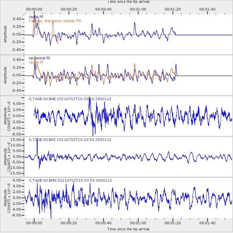
TAOE Taiohae, Marquises islands - Earthquake Result Viewer
*The percent match for this event was below the threshold and hence no stack was calculated.
| Earthquake location: |
Fiji Islands Region |
| Earthquake latitude/longitude: |
-21.8/-179.4 |
| Earthquake time(UTC): |
2021/07/02 (183) 20:14:38 GMT |
| Earthquake Depth: |
606 km |
| Earthquake Magnitude: |
6.1 Mww |
| Earthquake Catalog/Contributor: |
NEIC PDE/us |
|
| Network: |
G GEOSCOPE |
| Station: |
TAOE Taiohae, Marquises islands |
| Lat/Lon: |
8.85 S/140.15 W |
| Elevation: |
800 m |
|
| Distance: |
39.8 deg |
| Az: |
77.285 deg |
| Baz: |
246.514 deg |
| Ray Param: |
$rayparam |
*The percent match for this event was below the threshold and hence was not used in the summary stack. |
|
| Radial Match: |
69.13386 % |
| Radial Bump: |
400 |
| Transverse Match: |
52.768524 % |
| Transverse Bump: |
400 |
| SOD ConfigId: |
25131211 |
| Insert Time: |
2021-07-16 20:27:04.279 +0000 |
| GWidth: |
2.5 |
| Max Bumps: |
400 |
| Tol: |
0.001 |
|
Signal To Noise
| Channel | StoN | STA | LTA |
| G:TAOE:00:BHZ:20210702T20:20:50.260011Z | 3.9204214 | 4.699201E-6 | 1.1986469E-6 |
| G:TAOE:00:BHN:20210702T20:20:50.260011Z | 1.6414466 | 2.22047E-6 | 1.3527518E-6 |
| G:TAOE:00:BHE:20210702T20:20:50.260011Z | 2.1918826 | 2.8363522E-6 | 1.2940257E-6 |
| Arrivals |
| Ps | |
| PpPs | |
| PsPs/PpSs | |


