You are here: Home > Network List > II - Global Seismograph Network (GSN - IRIS/IDA) Stations List
> Station PFO Pinon Flat, California, USA > Earthquake Result Viewer
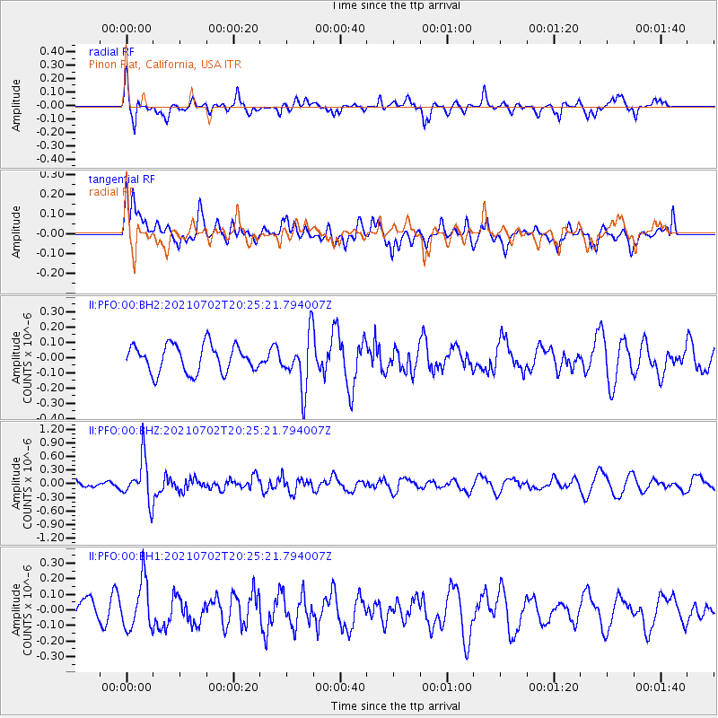
PFO Pinon Flat, California, USA - Earthquake Result Viewer
*The percent match for this event was below the threshold and hence no stack was calculated.
| Earthquake location: |
Fiji Islands Region |
| Earthquake latitude/longitude: |
-21.8/-179.4 |
| Earthquake time(UTC): |
2021/07/02 (183) 20:14:38 GMT |
| Earthquake Depth: |
606 km |
| Earthquake Magnitude: |
6.1 Mww |
| Earthquake Catalog/Contributor: |
NEIC PDE/us |
|
| Network: |
II Global Seismograph Network (GSN - IRIS/IDA) |
| Station: |
PFO Pinon Flat, California, USA |
| Lat/Lon: |
33.61 N/116.46 W |
| Elevation: |
1280 m |
|
| Distance: |
81.4 deg |
| Az: |
48.711 deg |
| Baz: |
236.782 deg |
| Ray Param: |
$rayparam |
*The percent match for this event was below the threshold and hence was not used in the summary stack. |
|
| Radial Match: |
58.71623 % |
| Radial Bump: |
300 |
| Transverse Match: |
48.524086 % |
| Transverse Bump: |
400 |
| SOD ConfigId: |
25131211 |
| Insert Time: |
2021-07-16 20:28:07.732 +0000 |
| GWidth: |
2.5 |
| Max Bumps: |
400 |
| Tol: |
0.001 |
|
Signal To Noise
| Channel | StoN | STA | LTA |
| II:PFO:00:BHZ:20210702T20:25:21.794007Z | 5.8382683 | 4.825069E-7 | 8.2645556E-8 |
| II:PFO:00:BH1:20210702T20:25:21.794007Z | 1.9035106 | 1.5818812E-7 | 8.310335E-8 |
| II:PFO:00:BH2:20210702T20:25:21.794007Z | 1.9967812 | 1.7816457E-7 | 8.922588E-8 |
| Arrivals |
| Ps | |
| PpPs | |
| PsPs/PpSs | |


