You are here: Home > Network List > UW - Pacific Northwest Regional Seismic Network Stations List
> Station IRON Crane, OR, USA > Earthquake Result Viewer
IRON Crane, OR, USA - Earthquake Result Viewer
*The percent match for this event was below the threshold and hence no stack was calculated.
| Earthquake location: |
Fiji Islands Region |
| Earthquake latitude/longitude: |
-21.8/-179.4 |
| Earthquake time(UTC): |
2021/07/02 (183) 20:14:38 GMT |
| Earthquake Depth: |
606 km |
| Earthquake Magnitude: |
6.1 Mww |
| Earthquake Catalog/Contributor: |
NEIC PDE/us |
|
| Network: |
UW Pacific Northwest Regional Seismic Network |
| Station: |
IRON Crane, OR, USA |
| Lat/Lon: |
43.36 N/118.47 W |
| Elevation: |
1226 m |
|
| Distance: |
85.6 deg |
| Az: |
39.726 deg |
| Baz: |
234.506 deg |
| Ray Param: |
$rayparam |
*The percent match for this event was below the threshold and hence was not used in the summary stack. |
|
| Radial Match: |
50.54148 % |
| Radial Bump: |
400 |
| Transverse Match: |
61.60104 % |
| Transverse Bump: |
400 |
| SOD ConfigId: |
25131211 |
| Insert Time: |
2021-07-16 20:37:02.238 +0000 |
| GWidth: |
2.5 |
| Max Bumps: |
400 |
| Tol: |
0.001 |
|
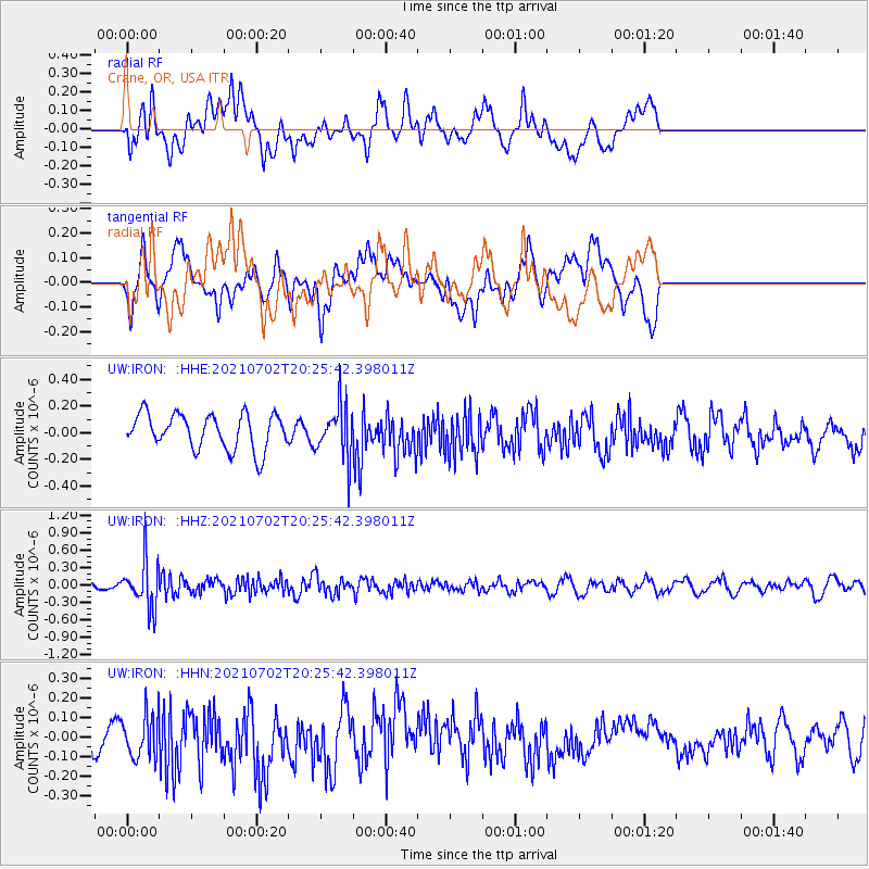
Signal To Noise
| Channel | StoN | STA | LTA |
| UW:IRON: :HHZ:20210702T20:25:42.398011Z | 5.5094028 | 4.0792335E-7 | 7.40413E-8 |
| UW:IRON: :HHN:20210702T20:25:42.398011Z | 1.2641889 | 1.12000215E-7 | 8.8594525E-8 |
| UW:IRON: :HHE:20210702T20:25:42.398011Z | 1.4930267 | 1.9552917E-7 | 1.309616E-7 |
| Arrivals |
| Ps | |
| PpPs | |
| PsPs/PpSs | |


