You are here: Home > Network List > WY - Yellowstone Wyoming Seismic Network Stations List
> Station YHH Holmes Hill, YNP, WY, USA > Earthquake Result Viewer
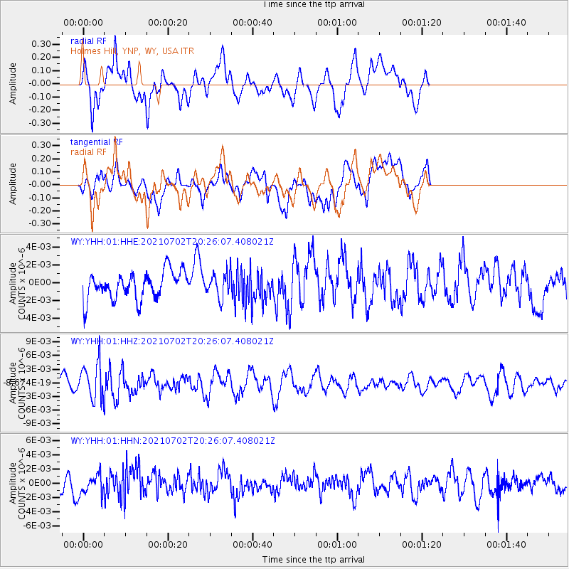
YHH Holmes Hill, YNP, WY, USA - Earthquake Result Viewer
*The percent match for this event was below the threshold and hence no stack was calculated.
| Earthquake location: |
Fiji Islands Region |
| Earthquake latitude/longitude: |
-21.8/-179.4 |
| Earthquake time(UTC): |
2021/07/02 (183) 20:14:38 GMT |
| Earthquake Depth: |
606 km |
| Earthquake Magnitude: |
6.1 Mww |
| Earthquake Catalog/Contributor: |
NEIC PDE/us |
|
| Network: |
WY Yellowstone Wyoming Seismic Network |
| Station: |
YHH Holmes Hill, YNP, WY, USA |
| Lat/Lon: |
44.79 N/110.85 W |
| Elevation: |
2717 m |
|
| Distance: |
91.0 deg |
| Az: |
41.505 deg |
| Baz: |
239.848 deg |
| Ray Param: |
$rayparam |
*The percent match for this event was below the threshold and hence was not used in the summary stack. |
|
| Radial Match: |
51.75492 % |
| Radial Bump: |
400 |
| Transverse Match: |
45.16657 % |
| Transverse Bump: |
400 |
| SOD ConfigId: |
25131211 |
| Insert Time: |
2021-07-16 20:38:07.322 +0000 |
| GWidth: |
2.5 |
| Max Bumps: |
400 |
| Tol: |
0.001 |
|
Signal To Noise
| Channel | StoN | STA | LTA |
| WY:YHH:01:HHZ:20210702T20:26:07.408021Z | 2.1738834 | 3.983521E-9 | 1.8324448E-9 |
| WY:YHH:01:HHN:20210702T20:26:07.408021Z | 0.875773 | 1.3309265E-9 | 1.5197161E-9 |
| WY:YHH:01:HHE:20210702T20:26:07.408021Z | 0.8842102 | 1.372035E-9 | 1.5517068E-9 |
| Arrivals |
| Ps | |
| PpPs | |
| PsPs/PpSs | |


