You are here: Home > Network List > US - United States National Seismic Network Stations List
> Station MSO Missoula, Montana, USA > Earthquake Result Viewer
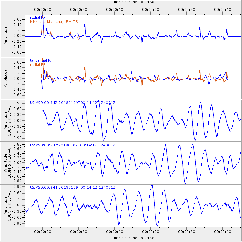
MSO Missoula, Montana, USA - Earthquake Result Viewer
*The percent match for this event was below the threshold and hence no stack was calculated.
| Earthquake location: |
Galapagos Islands Region |
| Earthquake latitude/longitude: |
1.7/-90.8 |
| Earthquake time(UTC): |
2018/01/09 (009) 00:05:54 GMT |
| Earthquake Depth: |
10 km |
| Earthquake Magnitude: |
5.8 Mww |
| Earthquake Catalog/Contributor: |
NEIC PDE/us |
|
| Network: |
US United States National Seismic Network |
| Station: |
MSO Missoula, Montana, USA |
| Lat/Lon: |
46.83 N/113.94 W |
| Elevation: |
1264 m |
|
| Distance: |
49.3 deg |
| Az: |
339.165 deg |
| Baz: |
148.815 deg |
| Ray Param: |
$rayparam |
*The percent match for this event was below the threshold and hence was not used in the summary stack. |
|
| Radial Match: |
53.07092 % |
| Radial Bump: |
302 |
| Transverse Match: |
44.602825 % |
| Transverse Bump: |
400 |
| SOD ConfigId: |
2528331 |
| Insert Time: |
2018-01-23 00:09:29.028 +0000 |
| GWidth: |
2.5 |
| Max Bumps: |
400 |
| Tol: |
0.001 |
|
Signal To Noise
| Channel | StoN | STA | LTA |
| US:MSO:00:BHZ:20180109T00:14:12.124001Z | 0.39721644 | 2.1838524E-7 | 5.49789E-7 |
| US:MSO:00:BH1:20180109T00:14:12.124001Z | 0.5067183 | 2.6222455E-7 | 5.174958E-7 |
| US:MSO:00:BH2:20180109T00:14:12.124001Z | 2.2293959 | 7.507721E-7 | 3.367603E-7 |
| Arrivals |
| Ps | |
| PpPs | |
| PsPs/PpSs | |


