You are here: Home > Network List > BK - Berkeley Digital Seismograph Network Stations List
> Station HUMO Hull Mountain, OR > Earthquake Result Viewer
HUMO Hull Mountain, OR - Earthquake Result Viewer
| Earthquake location: |
North Of Honduras |
| Earthquake latitude/longitude: |
17.5/-83.6 |
| Earthquake time(UTC): |
2018/01/10 (010) 02:51:31 GMT |
| Earthquake Depth: |
33 km |
| Earthquake Magnitude: |
7.8 Mi |
| Earthquake Catalog/Contributor: |
NEIC PDE/pt |
|
| Network: |
BK Berkeley Digital Seismograph Network |
| Station: |
HUMO Hull Mountain, OR |
| Lat/Lon: |
42.61 N/122.96 W |
| Elevation: |
555 m |
|
| Distance: |
41.8 deg |
| Az: |
315.275 deg |
| Baz: |
114.553 deg |
| Ray Param: |
0.07352598 |
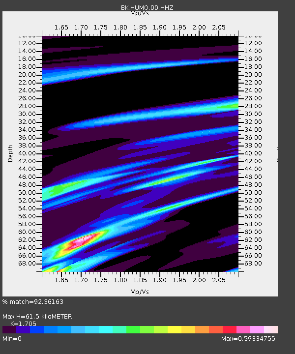
| Estimated Moho Depth: |
61.5 km |
| Estimated Crust Vp/Vs: |
1.71 |
| Assumed Crust Vp: |
6.522 km/s |
| Estimated Crust Vs: |
3.825 km/s |
| Estimated Crust Poisson's Ratio: |
0.24 |
|
| Radial Match: |
92.36163 % |
| Radial Bump: |
314 |
| Transverse Match: |
67.65967 % |
| Transverse Bump: |
400 |
| SOD ConfigId: |
2528331 |
| Insert Time: |
2018-01-24 02:51:42.421 +0000 |
| GWidth: |
2.5 |
| Max Bumps: |
400 |
| Tol: |
0.001 |
|

Signal To Noise
| Channel | StoN | STA | LTA |
| BK:HUMO:00:HHZ:20180110T02:58:46.537994Z | 1.8786001 | 1.6932655E-6 | 9.0134427E-7 |
| BK:HUMO:00:HHN:20180110T02:58:46.537994Z | 1.4844762 | 4.991458E-7 | 3.3624372E-7 |
| BK:HUMO:00:HHE:20180110T02:58:46.537994Z | 2.267722 | 1.1466623E-6 | 5.05645E-7 |
| Arrivals |
| Ps | 7.2 SECOND |
| PpPs | 24 SECOND |
| PsPs/PpSs | 31 SECOND |


