You are here: Home > Network List > IU - Global Seismograph Network (GSN - IRIS/USGS) Stations List
> Station MAKZ Makanchi, Kazakhstan > Earthquake Result Viewer
MAKZ Makanchi, Kazakhstan - Earthquake Result Viewer
| Earthquake location: |
Owen Fracture Zone Region |
| Earthquake latitude/longitude: |
14.2/56.8 |
| Earthquake time(UTC): |
2021/07/03 (184) 17:04:27 GMT |
| Earthquake Depth: |
10 km |
| Earthquake Magnitude: |
5.6 mww |
| Earthquake Catalog/Contributor: |
NEIC PDE/us |
|
| Network: |
IU Global Seismograph Network (GSN - IRIS/USGS) |
| Station: |
MAKZ Makanchi, Kazakhstan |
| Lat/Lon: |
46.81 N/81.98 E |
| Elevation: |
600 m |
|
| Distance: |
38.7 deg |
| Az: |
27.895 deg |
| Baz: |
221.336 deg |
| Ray Param: |
0.07542753 |
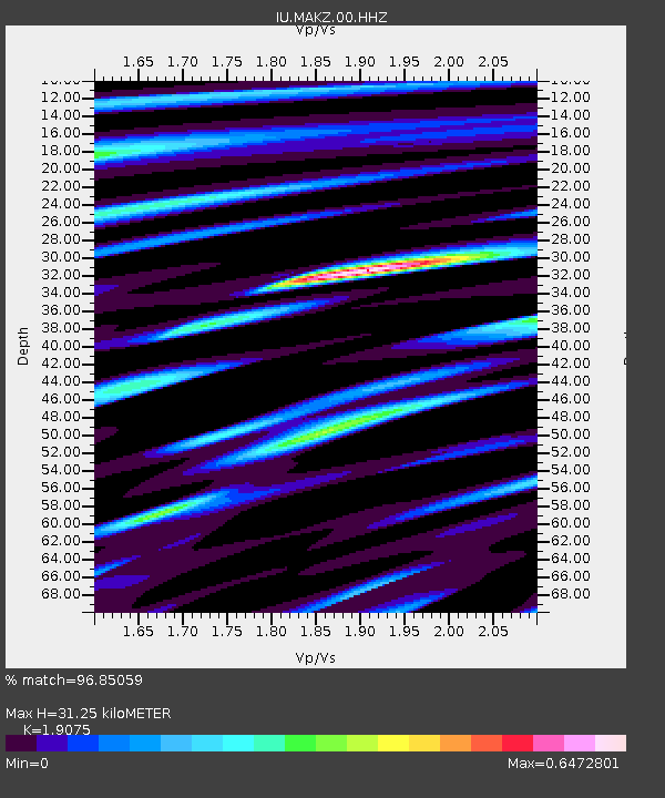
| Estimated Moho Depth: |
31.25 km |
| Estimated Crust Vp/Vs: |
1.91 |
| Assumed Crust Vp: |
6.571 km/s |
| Estimated Crust Vs: |
3.445 km/s |
| Estimated Crust Poisson's Ratio: |
0.31 |
|
| Radial Match: |
96.85059 % |
| Radial Bump: |
333 |
| Transverse Match: |
90.98951 % |
| Transverse Bump: |
400 |
| SOD ConfigId: |
25131211 |
| Insert Time: |
2021-07-17 17:08:44.933 +0000 |
| GWidth: |
2.5 |
| Max Bumps: |
400 |
| Tol: |
0.001 |
|

Signal To Noise
| Channel | StoN | STA | LTA |
| IU:MAKZ:00:HHZ:20210703T17:11:20.558001Z | 10.390079 | 3.6955328E-7 | 3.55679E-8 |
| IU:MAKZ:00:HH1:20210703T17:11:20.558001Z | 7.719055 | 1.6717247E-7 | 2.1657115E-8 |
| IU:MAKZ:00:HH2:20210703T17:11:20.558001Z | 7.589921 | 1.2032415E-7 | 1.5853148E-8 |
| Arrivals |
| Ps | 4.6 SECOND |
| PpPs | 13 SECOND |
| PsPs/PpSs | 18 SECOND |


