You are here: Home > Network List > KO - Kandilli Observatory Digital Broadband Seismic Network Stations List
> Station BALB Balikesir-Turkiye > Earthquake Result Viewer
BALB Balikesir-Turkiye - Earthquake Result Viewer
| Earthquake location: |
Owen Fracture Zone Region |
| Earthquake latitude/longitude: |
14.2/56.8 |
| Earthquake time(UTC): |
2021/07/03 (184) 17:04:27 GMT |
| Earthquake Depth: |
10 km |
| Earthquake Magnitude: |
5.6 mww |
| Earthquake Catalog/Contributor: |
NEIC PDE/us |
|
| Network: |
KO Kandilli Observatory Digital Broadband Seismic Network |
| Station: |
BALB Balikesir-Turkiye |
| Lat/Lon: |
39.64 N/27.88 E |
| Elevation: |
120 m |
|
| Distance: |
35.8 deg |
| Az: |
320.405 deg |
| Baz: |
126.834 deg |
| Ray Param: |
0.07702943 |
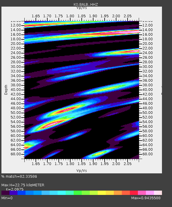
| Estimated Moho Depth: |
22.75 km |
| Estimated Crust Vp/Vs: |
2.10 |
| Assumed Crust Vp: |
6.155 km/s |
| Estimated Crust Vs: |
2.934 km/s |
| Estimated Crust Poisson's Ratio: |
0.35 |
|
| Radial Match: |
82.33586 % |
| Radial Bump: |
400 |
| Transverse Match: |
66.35983 % |
| Transverse Bump: |
400 |
| SOD ConfigId: |
25131211 |
| Insert Time: |
2021-07-17 17:09:09.998 +0000 |
| GWidth: |
2.5 |
| Max Bumps: |
400 |
| Tol: |
0.001 |
|

Signal To Noise
| Channel | StoN | STA | LTA |
| KO:BALB: :HHZ:20210703T17:10:55.930011Z | 3.2199519 | 2.764526E-7 | 8.585613E-8 |
| KO:BALB: :HHN:20210703T17:10:55.930011Z | 1.1296381 | 7.7584154E-8 | 6.868054E-8 |
| KO:BALB: :HHE:20210703T17:10:55.930011Z | 1.3464305 | 1.0367053E-7 | 7.6996564E-8 |
| Arrivals |
| Ps | 4.3 SECOND |
| PpPs | 11 SECOND |
| PsPs/PpSs | 15 SECOND |


