You are here: Home > Network List > IU - Global Seismograph Network (GSN - IRIS/USGS) Stations List
> Station JOHN Johnston Island, USA > Earthquake Result Viewer
JOHN Johnston Island, USA - Earthquake Result Viewer
| Earthquake location: |
North Of Honduras |
| Earthquake latitude/longitude: |
17.5/-83.6 |
| Earthquake time(UTC): |
2018/01/10 (010) 02:51:31 GMT |
| Earthquake Depth: |
33 km |
| Earthquake Magnitude: |
7.8 Mi |
| Earthquake Catalog/Contributor: |
NEIC PDE/pt |
|
| Network: |
IU Global Seismograph Network (GSN - IRIS/USGS) |
| Station: |
JOHN Johnston Island, USA |
| Lat/Lon: |
16.73 N/169.53 W |
| Elevation: |
2.0 m |
|
| Distance: |
81.4 deg |
| Az: |
284.822 deg |
| Baz: |
74.318 deg |
| Ray Param: |
0.047578778 |
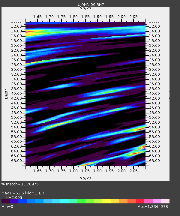
| Estimated Moho Depth: |
62.5 km |
| Estimated Crust Vp/Vs: |
2.10 |
| Assumed Crust Vp: |
4.24 km/s |
| Estimated Crust Vs: |
2.024 km/s |
| Estimated Crust Poisson's Ratio: |
0.35 |
|
| Radial Match: |
83.78975 % |
| Radial Bump: |
400 |
| Transverse Match: |
66.191696 % |
| Transverse Bump: |
400 |
| SOD ConfigId: |
2528331 |
| Insert Time: |
2018-01-24 02:52:19.671 +0000 |
| GWidth: |
2.5 |
| Max Bumps: |
400 |
| Tol: |
0.001 |
|
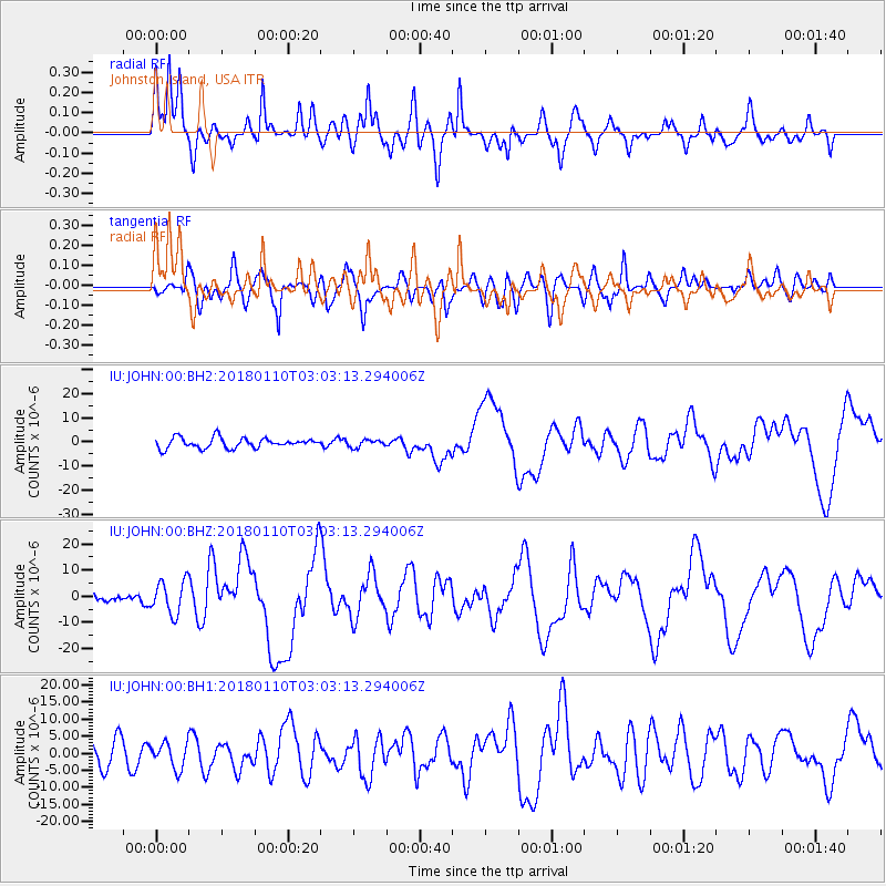
Signal To Noise
| Channel | StoN | STA | LTA |
| IU:JOHN:00:BHZ:20180110T03:03:13.294006Z | 2.4368517 | 6.298962E-6 | 2.584877E-6 |
| IU:JOHN:00:BH1:20180110T03:03:13.294006Z | 1.1749462 | 3.7363297E-6 | 3.1800007E-6 |
| IU:JOHN:00:BH2:20180110T03:03:13.294006Z | 0.7109879 | 1.5192894E-6 | 2.136871E-6 |
| Arrivals |
| Ps | 16 SECOND |
| PpPs | 45 SECOND |
| PsPs/PpSs | 61 SECOND |


