You are here: Home > Network List > US - United States National Seismic Network Stations List
> Station ERPA Erie, Pennsylvania, USA > Earthquake Result Viewer
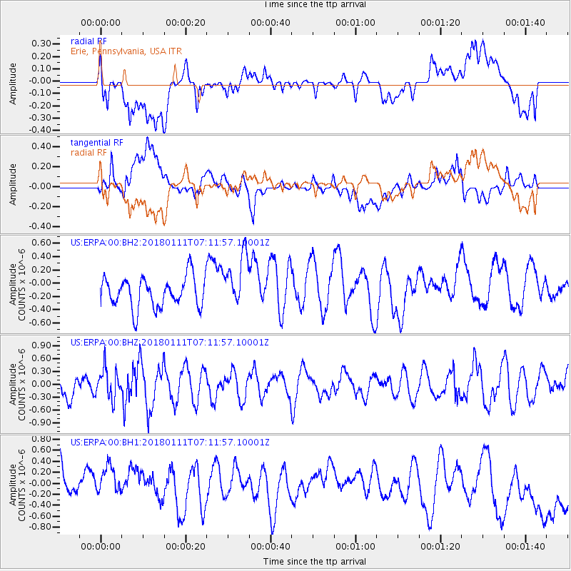
ERPA Erie, Pennsylvania, USA - Earthquake Result Viewer
*The percent match for this event was below the threshold and hence no stack was calculated.
| Earthquake location: |
Iran-Iraq Border Region |
| Earthquake latitude/longitude: |
33.8/45.7 |
| Earthquake time(UTC): |
2018/01/11 (011) 06:59:31 GMT |
| Earthquake Depth: |
10 km |
| Earthquake Magnitude: |
5.5 Mww |
| Earthquake Catalog/Contributor: |
NEIC PDE/us |
|
| Network: |
US United States National Seismic Network |
| Station: |
ERPA Erie, Pennsylvania, USA |
| Lat/Lon: |
42.12 N/79.99 W |
| Elevation: |
306 m |
|
| Distance: |
89.6 deg |
| Az: |
322.849 deg |
| Baz: |
42.548 deg |
| Ray Param: |
$rayparam |
*The percent match for this event was below the threshold and hence was not used in the summary stack. |
|
| Radial Match: |
46.66465 % |
| Radial Bump: |
400 |
| Transverse Match: |
38.695087 % |
| Transverse Bump: |
400 |
| SOD ConfigId: |
2528331 |
| Insert Time: |
2018-01-25 07:01:52.597 +0000 |
| GWidth: |
2.5 |
| Max Bumps: |
400 |
| Tol: |
0.001 |
|
Signal To Noise
| Channel | StoN | STA | LTA |
| US:ERPA:00:BHZ:20180111T07:11:57.10001Z | 0.91589814 | 3.4735305E-7 | 3.7924855E-7 |
| US:ERPA:00:BH1:20180111T07:11:57.10001Z | 0.541035 | 2.5599672E-7 | 4.7316115E-7 |
| US:ERPA:00:BH2:20180111T07:11:57.10001Z | 1.7823701 | 4.0679595E-7 | 2.2823316E-7 |
| Arrivals |
| Ps | |
| PpPs | |
| PsPs/PpSs | |


