You are here: Home > Network List > KZ - Kazakhstan Network Stations List
> Station MKAR Makanchi array,MK31, Kazakhstan > Earthquake Result Viewer
MKAR Makanchi array,MK31, Kazakhstan - Earthquake Result Viewer
| Earthquake location: |
Solomon Islands |
| Earthquake latitude/longitude: |
-6.0/154.8 |
| Earthquake time(UTC): |
2003/06/12 (163) 08:59:20 GMT |
| Earthquake Depth: |
186 km |
| Earthquake Magnitude: |
5.9 MB, 6.3 MW, 6.3 MW |
| Earthquake Catalog/Contributor: |
WHDF/NEIC |
|
| Network: |
KZ Kazakhstan Network |
| Station: |
MKAR Makanchi array,MK31, Kazakhstan |
| Lat/Lon: |
46.79 N/82.29 E |
| Elevation: |
615 m |
|
| Distance: |
82.5 deg |
| Az: |
318.638 deg |
| Baz: |
106.94 deg |
| Ray Param: |
0.046402004 |
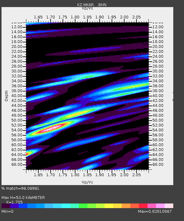
| Estimated Moho Depth: |
53.0 km |
| Estimated Crust Vp/Vs: |
1.71 |
| Assumed Crust Vp: |
6.688 km/s |
| Estimated Crust Vs: |
3.923 km/s |
| Estimated Crust Poisson's Ratio: |
0.24 |
|
| Radial Match: |
96.06961 % |
| Radial Bump: |
400 |
| Transverse Match: |
93.09418 % |
| Transverse Bump: |
400 |
| SOD ConfigId: |
4714 |
| Insert Time: |
2010-03-09 09:52:39.157 +0000 |
| GWidth: |
2.5 |
| Max Bumps: |
400 |
| Tol: |
0.001 |
|

Signal To Noise
| Channel | StoN | STA | LTA |
| KZ:MKAR: :BHN:20030612T09:10:50.75001Z | 24.920538 | 8.590186E-7 | 3.4470307E-8 |
| KZ:MKAR: :BHE:20030612T09:10:50.75001Z | 56.267696 | 2.9219314E-6 | 5.1929106E-8 |
| KZ:MKAR: :BHZ:20030612T09:10:50.75001Z | 146.44562 | 9.0394515E-6 | 6.172565E-8 |
| Arrivals |
| Ps | 5.8 SECOND |
| PpPs | 21 SECOND |
| PsPs/PpSs | 27 SECOND |


