You are here: Home > Network List > IU - Global Seismograph Network (GSN - IRIS/USGS) Stations List
> Station JOHN Johnston Island, USA > Earthquake Result Viewer
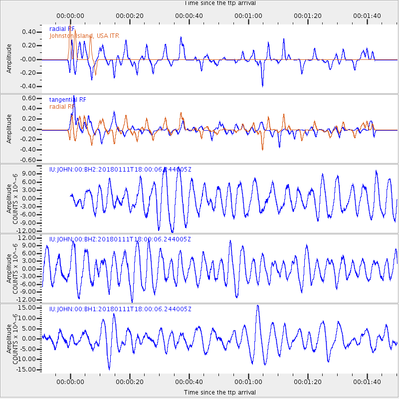
JOHN Johnston Island, USA - Earthquake Result Viewer
*The percent match for this event was below the threshold and hence no stack was calculated.
| Earthquake location: |
South Of Fiji Islands |
| Earthquake latitude/longitude: |
-23.9/180.0 |
| Earthquake time(UTC): |
2018/01/11 (011) 17:53:33 GMT |
| Earthquake Depth: |
508 km |
| Earthquake Magnitude: |
5.5 Mww |
| Earthquake Catalog/Contributor: |
NEIC PDE/us |
|
| Network: |
IU Global Seismograph Network (GSN - IRIS/USGS) |
| Station: |
JOHN Johnston Island, USA |
| Lat/Lon: |
16.73 N/169.53 W |
| Elevation: |
2.0 m |
|
| Distance: |
41.7 deg |
| Az: |
15.251 deg |
| Baz: |
194.55 deg |
| Ray Param: |
$rayparam |
*The percent match for this event was below the threshold and hence was not used in the summary stack. |
|
| Radial Match: |
53.96509 % |
| Radial Bump: |
400 |
| Transverse Match: |
60.59601 % |
| Transverse Bump: |
400 |
| SOD ConfigId: |
2528331 |
| Insert Time: |
2018-01-25 17:54:31.132 +0000 |
| GWidth: |
2.5 |
| Max Bumps: |
400 |
| Tol: |
0.001 |
|
Signal To Noise
| Channel | StoN | STA | LTA |
| IU:JOHN:00:BHZ:20180111T18:00:06.244005Z | 1.5255035 | 6.720222E-6 | 4.4052485E-6 |
| IU:JOHN:00:BH1:20180111T18:00:06.244005Z | 0.41683167 | 2.2376287E-6 | 5.368183E-6 |
| IU:JOHN:00:BH2:20180111T18:00:06.244005Z | 2.7597015 | 8.723521E-6 | 3.1610377E-6 |
| Arrivals |
| Ps | |
| PpPs | |
| PsPs/PpSs | |


