You are here: Home > Network List > KZ - Kazakhstan Network Stations List
> Station MKAR Makanchi array,MK31, Kazakhstan > Earthquake Result Viewer
MKAR Makanchi array,MK31, Kazakhstan - Earthquake Result Viewer
| Earthquake location: |
Banda Sea |
| Earthquake latitude/longitude: |
-7.4/128.4 |
| Earthquake time(UTC): |
2004/04/17 (108) 15:58:24 GMT |
| Earthquake Depth: |
129 km |
| Earthquake Magnitude: |
6.1 MB, 5.8 MW, 5.7 MW |
| Earthquake Catalog/Contributor: |
WHDF/NEIC |
|
| Network: |
KZ Kazakhstan Network |
| Station: |
MKAR Makanchi array,MK31, Kazakhstan |
| Lat/Lon: |
46.79 N/82.29 E |
| Elevation: |
615 m |
|
| Distance: |
67.6 deg |
| Az: |
327.647 deg |
| Baz: |
129.416 deg |
| Ray Param: |
0.05647711 |
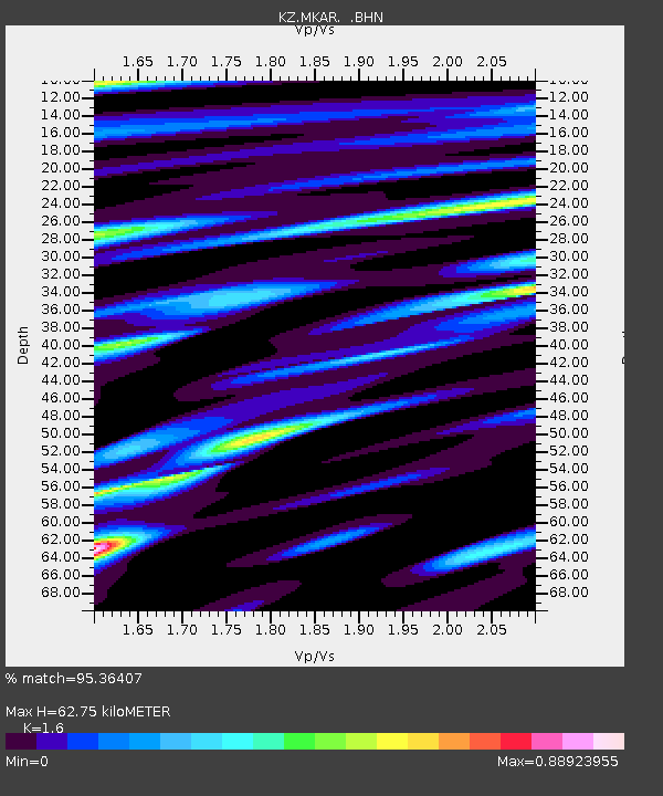
| Estimated Moho Depth: |
62.75 km |
| Estimated Crust Vp/Vs: |
1.60 |
| Assumed Crust Vp: |
6.688 km/s |
| Estimated Crust Vs: |
4.18 km/s |
| Estimated Crust Poisson's Ratio: |
0.18 |
|
| Radial Match: |
95.36407 % |
| Radial Bump: |
400 |
| Transverse Match: |
91.44498 % |
| Transverse Bump: |
400 |
| SOD ConfigId: |
2459 |
| Insert Time: |
2010-03-09 09:53:55.724 +0000 |
| GWidth: |
2.5 |
| Max Bumps: |
400 |
| Tol: |
0.001 |
|

Signal To Noise
| Channel | StoN | STA | LTA |
| KZ:MKAR: :BHN:20040417T16:08:36.899001Z | 40.106434 | 2.3018954E-6 | 5.7394665E-8 |
| KZ:MKAR: :BHE:20040417T16:08:36.899001Z | 32.12192 | 2.330378E-6 | 7.25479E-8 |
| KZ:MKAR: :BHZ:20040417T16:08:36.899001Z | 112.63415 | 7.6264396E-6 | 6.7709834E-8 |
| Arrivals |
| Ps | 5.9 SECOND |
| PpPs | 23 SECOND |
| PsPs/PpSs | 29 SECOND |


