You are here: Home > Network List > KZ - Kazakhstan Network Stations List
> Station MKAR Makanchi array,MK31, Kazakhstan > Earthquake Result Viewer
MKAR Makanchi array,MK31, Kazakhstan - Earthquake Result Viewer
| Earthquake location: |
Irian Jaya Region, Indonesia |
| Earthquake latitude/longitude: |
-0.7/134.4 |
| Earthquake time(UTC): |
2004/10/06 (280) 22:30:56 GMT |
| Earthquake Depth: |
10 km |
| Earthquake Magnitude: |
5.7 MB, 6.0 MS, 6.2 MW, 6.1 MW |
| Earthquake Catalog/Contributor: |
WHDF/NEIC |
|
| Network: |
KZ Kazakhstan Network |
| Station: |
MKAR Makanchi array,MK31, Kazakhstan |
| Lat/Lon: |
46.79 N/82.29 E |
| Elevation: |
615 m |
|
| Distance: |
65.6 deg |
| Az: |
323.44 deg |
| Baz: |
119.9 deg |
| Ray Param: |
0.058171466 |
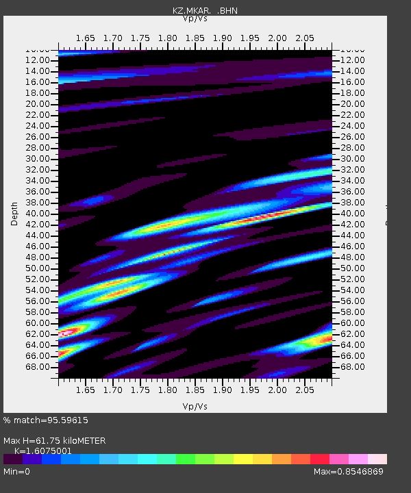
| Estimated Moho Depth: |
61.75 km |
| Estimated Crust Vp/Vs: |
1.61 |
| Assumed Crust Vp: |
6.688 km/s |
| Estimated Crust Vs: |
4.16 km/s |
| Estimated Crust Poisson's Ratio: |
0.18 |
|
| Radial Match: |
95.59615 % |
| Radial Bump: |
400 |
| Transverse Match: |
76.013855 % |
| Transverse Bump: |
400 |
| SOD ConfigId: |
2459 |
| Insert Time: |
2010-03-09 09:54:08.512 +0000 |
| GWidth: |
2.5 |
| Max Bumps: |
400 |
| Tol: |
0.001 |
|

Signal To Noise
| Channel | StoN | STA | LTA |
| KZ:MKAR: :BHN:20041006T22:41:09.673999Z | 2.466764 | 3.9022132E-7 | 1.5819158E-7 |
| KZ:MKAR: :BHE:20041006T22:41:09.673999Z | 2.5795884 | 3.9638635E-7 | 1.5366264E-7 |
| KZ:MKAR: :BHZ:20041006T22:41:09.673999Z | 12.136025 | 1.2682453E-6 | 1.04502526E-7 |
| Arrivals |
| Ps | 5.9 SECOND |
| PpPs | 23 SECOND |
| PsPs/PpSs | 29 SECOND |


