You are here: Home > Network List > US - United States National Seismic Network Stations List
> Station CBKS Cedar Bluff, Kansas, USA > Earthquake Result Viewer
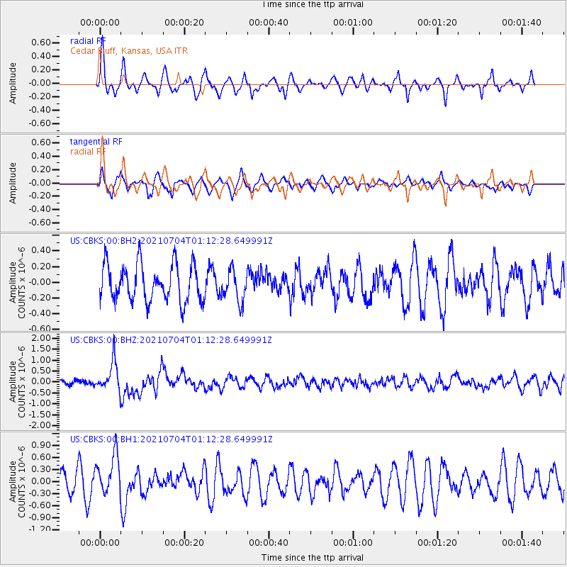
CBKS Cedar Bluff, Kansas, USA - Earthquake Result Viewer
*The percent match for this event was below the threshold and hence no stack was calculated.
| Earthquake location: |
Near Coast Of Central Chile |
| Earthquake latitude/longitude: |
-28.8/-71.7 |
| Earthquake time(UTC): |
2021/07/04 (185) 01:01:35 GMT |
| Earthquake Depth: |
10 km |
| Earthquake Magnitude: |
6.0 Mww |
| Earthquake Catalog/Contributor: |
NEIC PDE/us |
|
| Network: |
US United States National Seismic Network |
| Station: |
CBKS Cedar Bluff, Kansas, USA |
| Lat/Lon: |
38.81 N/99.74 W |
| Elevation: |
677 m |
|
| Distance: |
72.2 deg |
| Az: |
337.27 deg |
| Baz: |
154.262 deg |
| Ray Param: |
$rayparam |
*The percent match for this event was below the threshold and hence was not used in the summary stack. |
|
| Radial Match: |
67.8681 % |
| Radial Bump: |
400 |
| Transverse Match: |
64.86851 % |
| Transverse Bump: |
400 |
| SOD ConfigId: |
25131211 |
| Insert Time: |
2021-07-18 01:22:31.341 +0000 |
| GWidth: |
2.5 |
| Max Bumps: |
400 |
| Tol: |
0.001 |
|
Signal To Noise
| Channel | StoN | STA | LTA |
| US:CBKS:00:BHZ:20210704T01:12:28.649991Z | 5.90636 | 6.860186E-7 | 1.1614913E-7 |
| US:CBKS:00:BH1:20210704T01:12:28.649991Z | 2.389657 | 5.0250907E-7 | 2.1028501E-7 |
| US:CBKS:00:BH2:20210704T01:12:28.649991Z | 0.85303676 | 2.0092887E-7 | 2.3554539E-7 |
| Arrivals |
| Ps | |
| PpPs | |
| PsPs/PpSs | |


