You are here: Home > Network List > US - United States National Seismic Network Stations List
> Station MNTX Cornudas Mountains, Texas, USA > Earthquake Result Viewer
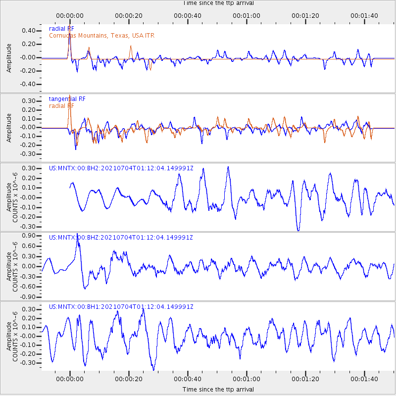
MNTX Cornudas Mountains, Texas, USA - Earthquake Result Viewer
*The percent match for this event was below the threshold and hence no stack was calculated.
| Earthquake location: |
Near Coast Of Central Chile |
| Earthquake latitude/longitude: |
-28.8/-71.7 |
| Earthquake time(UTC): |
2021/07/04 (185) 01:01:35 GMT |
| Earthquake Depth: |
10 km |
| Earthquake Magnitude: |
6.0 Mww |
| Earthquake Catalog/Contributor: |
NEIC PDE/us |
|
| Network: |
US United States National Seismic Network |
| Station: |
MNTX Cornudas Mountains, Texas, USA |
| Lat/Lon: |
31.70 N/105.38 W |
| Elevation: |
404 m |
|
| Distance: |
68.2 deg |
| Az: |
329.339 deg |
| Baz: |
148.313 deg |
| Ray Param: |
$rayparam |
*The percent match for this event was below the threshold and hence was not used in the summary stack. |
|
| Radial Match: |
66.63953 % |
| Radial Bump: |
400 |
| Transverse Match: |
71.00017 % |
| Transverse Bump: |
400 |
| SOD ConfigId: |
25131211 |
| Insert Time: |
2021-07-18 01:23:07.618 +0000 |
| GWidth: |
2.5 |
| Max Bumps: |
400 |
| Tol: |
0.001 |
|
Signal To Noise
| Channel | StoN | STA | LTA |
| US:MNTX:00:BHZ:20210704T01:12:04.149991Z | 4.6903663 | 4.1775522E-7 | 8.906665E-8 |
| US:MNTX:00:BH1:20210704T01:12:04.149991Z | 1.2552199 | 1.5836618E-7 | 1.2616607E-7 |
| US:MNTX:00:BH2:20210704T01:12:04.149991Z | 0.9977737 | 7.263924E-8 | 7.280132E-8 |
| Arrivals |
| Ps | |
| PpPs | |
| PsPs/PpSs | |


