You are here: Home > Network List > UW - Pacific Northwest Regional Seismic Network Stations List
> Station HOOD Mt Hood Meadows, OR CREST BB SMO > Earthquake Result Viewer
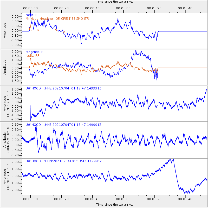
HOOD Mt Hood Meadows, OR CREST BB SMO - Earthquake Result Viewer
*The percent match for this event was below the threshold and hence no stack was calculated.
| Earthquake location: |
Near Coast Of Central Chile |
| Earthquake latitude/longitude: |
-28.8/-71.7 |
| Earthquake time(UTC): |
2021/07/04 (185) 01:01:35 GMT |
| Earthquake Depth: |
10 km |
| Earthquake Magnitude: |
6.0 Mww |
| Earthquake Catalog/Contributor: |
NEIC PDE/us |
|
| Network: |
UW Pacific Northwest Regional Seismic Network |
| Station: |
HOOD Mt Hood Meadows, OR CREST BB SMO |
| Lat/Lon: |
45.32 N/121.65 W |
| Elevation: |
1520 m |
|
| Distance: |
86.6 deg |
| Az: |
327.22 deg |
| Baz: |
137.64 deg |
| Ray Param: |
$rayparam |
*The percent match for this event was below the threshold and hence was not used in the summary stack. |
|
| Radial Match: |
38.5368 % |
| Radial Bump: |
400 |
| Transverse Match: |
26.551298 % |
| Transverse Bump: |
400 |
| SOD ConfigId: |
25131211 |
| Insert Time: |
2021-07-18 01:24:45.377 +0000 |
| GWidth: |
2.5 |
| Max Bumps: |
400 |
| Tol: |
0.001 |
|
Signal To Noise
| Channel | StoN | STA | LTA |
| UW:HOOD: :HHZ:20210704T01:13:47.149991Z | 2.3074887 | 3.4486925E-7 | 1.4945653E-7 |
| UW:HOOD: :HHN:20210704T01:13:47.149991Z | 1.2386862 | 6.350054E-7 | 5.126443E-7 |
| UW:HOOD: :HHE:20210704T01:13:47.149991Z | 1.2355533 | 8.458356E-7 | 6.845804E-7 |
| Arrivals |
| Ps | |
| PpPs | |
| PsPs/PpSs | |


