You are here: Home > Network List > AG - Arkansas Seismic Network Stations List
> Station LCAR Lake Charles,AR > Earthquake Result Viewer
LCAR Lake Charles,AR - Earthquake Result Viewer
| Earthquake location: |
Near Coast Of Peru |
| Earthquake latitude/longitude: |
-15.8/-74.7 |
| Earthquake time(UTC): |
2018/01/14 (014) 09:18:45 GMT |
| Earthquake Depth: |
36 km |
| Earthquake Magnitude: |
7.1 mww |
| Earthquake Catalog/Contributor: |
NEIC PDE/us |
|
| Network: |
AG Arkansas Seismic Network |
| Station: |
LCAR Lake Charles,AR |
| Lat/Lon: |
36.07 N/91.15 W |
| Elevation: |
103 m |
|
| Distance: |
53.9 deg |
| Az: |
343.534 deg |
| Baz: |
160.315 deg |
| Ray Param: |
0.065750115 |
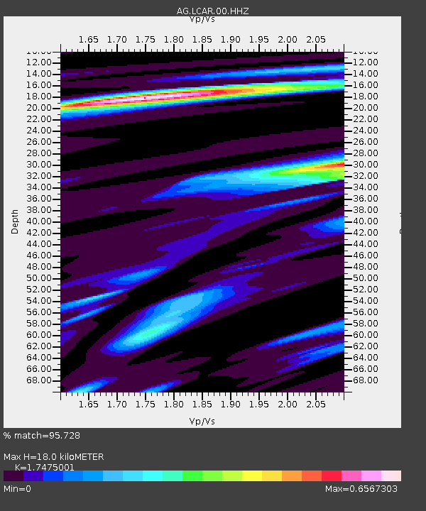
| Estimated Moho Depth: |
18.0 km |
| Estimated Crust Vp/Vs: |
1.75 |
| Assumed Crust Vp: |
6.53 km/s |
| Estimated Crust Vs: |
3.737 km/s |
| Estimated Crust Poisson's Ratio: |
0.26 |
|
| Radial Match: |
95.728 % |
| Radial Bump: |
213 |
| Transverse Match: |
90.78853 % |
| Transverse Bump: |
400 |
| SOD ConfigId: |
2537391 |
| Insert Time: |
2018-01-28 09:18:53.521 +0000 |
| GWidth: |
2.5 |
| Max Bumps: |
400 |
| Tol: |
0.001 |
|
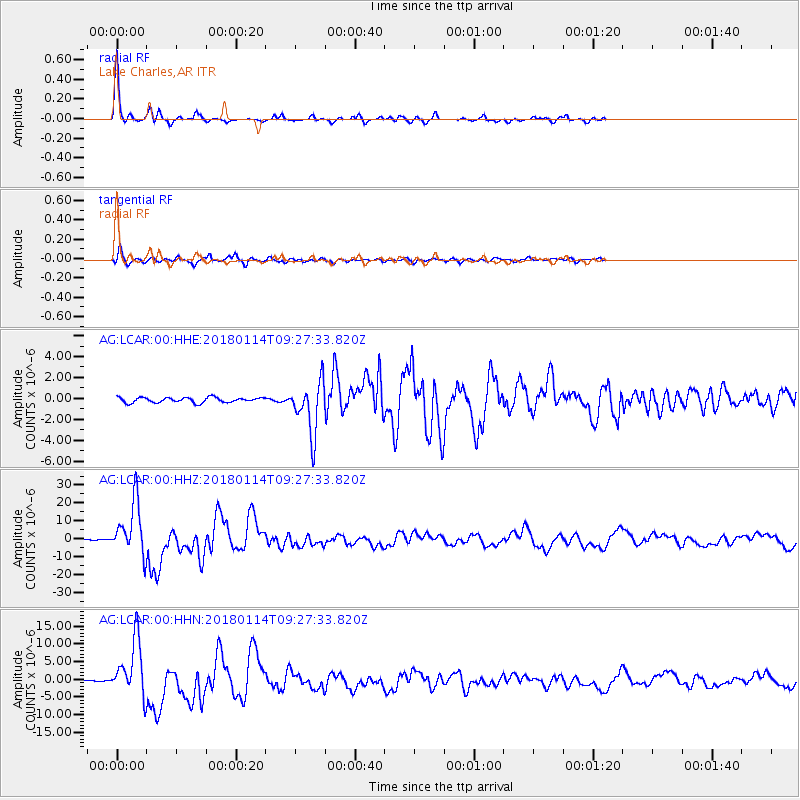
Signal To Noise
| Channel | StoN | STA | LTA |
| AG:LCAR:00:HHZ:20180114T09:27:33.820Z | 42.900715 | 1.4733933E-5 | 3.434426E-7 |
| AG:LCAR:00:HHN:20180114T09:27:33.820Z | 51.1784 | 7.921765E-6 | 1.5478729E-7 |
| AG:LCAR:00:HHE:20180114T09:27:33.820Z | 10.108358 | 2.4921546E-6 | 2.4654395E-7 |
| Arrivals |
| Ps | 2.2 SECOND |
| PpPs | 7.2 SECOND |
| PsPs/PpSs | 9.3 SECOND |


