You are here: Home > Network List > AG - Arkansas Seismic Network Stations List
> Station X40A Basin Creek Farm, Marlvern, AR > Earthquake Result Viewer
X40A Basin Creek Farm, Marlvern, AR - Earthquake Result Viewer

| Earthquake location: |
Near Coast Of Peru |
| Earthquake latitude/longitude: |
-15.8/-74.7 |
| Earthquake time(UTC): |
2018/01/14 (014) 09:18:45 GMT |
| Earthquake Depth: |
36 km |
| Earthquake Magnitude: |
7.1 mww |
| Earthquake Catalog/Contributor: |
NEIC PDE/us |
|
| Network: |
AG Arkansas Seismic Network |
| Station: |
X40A Basin Creek Farm, Marlvern, AR |
| Lat/Lon: |
34.49 N/92.83 W |
| Elevation: |
158 m |
|
| Distance: |
52.9 deg |
| Az: |
341.232 deg |
| Baz: |
157.975 deg |
| Ray Param: |
0.06641058 |
| Estimated Moho Depth: |
25.5 km |
| Estimated Crust Vp/Vs: |
1.60 |
| Assumed Crust Vp: |
6.498 km/s |
| Estimated Crust Vs: |
4.061 km/s |
| Estimated Crust Poisson's Ratio: |
0.18 |
|
| Radial Match: |
94.57499 % |
| Radial Bump: |
312 |
| Transverse Match: |
83.816826 % |
| Transverse Bump: |
400 |
| SOD ConfigId: |
2537391 |
| Insert Time: |
2018-01-28 09:18:59.265 +0000 |
| GWidth: |
2.5 |
| Max Bumps: |
400 |
| Tol: |
0.001 |
|
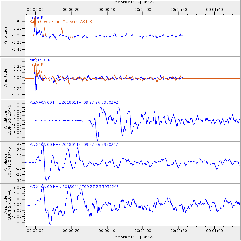
Signal To Noise
| Channel | StoN | STA | LTA |
| AG:X40A:00:HHZ:20180114T09:27:26.595024Z | 84.65316 | 1.4311648E-5 | 1.6906218E-7 |
| AG:X40A:00:HHN:20180114T09:27:26.595024Z | 39.275635 | 5.2333758E-6 | 1.3324738E-7 |
| AG:X40A:00:HHE:20180114T09:27:26.595024Z | 19.094793 | 3.2796934E-6 | 1.7175851E-7 |
| Arrivals |
| Ps | 2.5 SECOND |
| PpPs | 9.6 SECOND |
| PsPs/PpSs | 12 SECOND |


