You are here: Home > Network List > CO - South Carolina Seismic Network Stations List
> Station CASEE Lake Jocassee, SC, USA > Earthquake Result Viewer
CASEE Lake Jocassee, SC, USA - Earthquake Result Viewer
| Earthquake location: |
Near Coast Of Peru |
| Earthquake latitude/longitude: |
-15.8/-74.7 |
| Earthquake time(UTC): |
2018/01/14 (014) 09:18:45 GMT |
| Earthquake Depth: |
36 km |
| Earthquake Magnitude: |
7.1 mww |
| Earthquake Catalog/Contributor: |
NEIC PDE/us |
|
| Network: |
CO South Carolina Seismic Network |
| Station: |
CASEE Lake Jocassee, SC, USA |
| Lat/Lon: |
34.99 N/82.93 W |
| Elevation: |
385 m |
|
| Distance: |
51.1 deg |
| Az: |
351.357 deg |
| Baz: |
169.85 deg |
| Ray Param: |
0.067565486 |
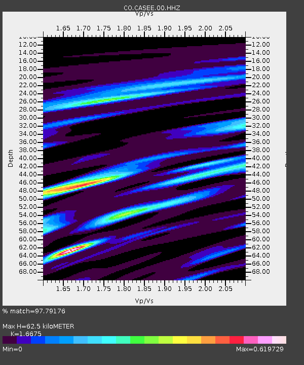
| Estimated Moho Depth: |
62.5 km |
| Estimated Crust Vp/Vs: |
1.67 |
| Assumed Crust Vp: |
6.35 km/s |
| Estimated Crust Vs: |
3.808 km/s |
| Estimated Crust Poisson's Ratio: |
0.22 |
|
| Radial Match: |
97.79176 % |
| Radial Bump: |
246 |
| Transverse Match: |
84.905266 % |
| Transverse Bump: |
400 |
| SOD ConfigId: |
2537391 |
| Insert Time: |
2018-01-28 09:19:22.811 +0000 |
| GWidth: |
2.5 |
| Max Bumps: |
400 |
| Tol: |
0.001 |
|

Signal To Noise
| Channel | StoN | STA | LTA |
| CO:CASEE:00:HHZ:20180114T09:27:13.378014Z | 30.718824 | 1.4327358E-5 | 4.664032E-7 |
| CO:CASEE:00:HHN:20180114T09:27:13.378014Z | 35.439224 | 8.343435E-6 | 2.3542938E-7 |
| CO:CASEE:00:HHE:20180114T09:27:13.378014Z | 4.426342 | 1.8506006E-6 | 4.1808804E-7 |
| Arrivals |
| Ps | 7.0 SECOND |
| PpPs | 25 SECOND |
| PsPs/PpSs | 32 SECOND |


