You are here: Home > Network List > CO - South Carolina Seismic Network Stations List
> Station SUMMV Summerville Airport, SC, USA > Earthquake Result Viewer
SUMMV Summerville Airport, SC, USA - Earthquake Result Viewer

| Earthquake location: |
Near Coast Of Peru |
| Earthquake latitude/longitude: |
-15.8/-74.7 |
| Earthquake time(UTC): |
2018/01/14 (014) 09:18:45 GMT |
| Earthquake Depth: |
36 km |
| Earthquake Magnitude: |
7.1 mww |
| Earthquake Catalog/Contributor: |
NEIC PDE/us |
|
| Network: |
CO South Carolina Seismic Network |
| Station: |
SUMMV Summerville Airport, SC, USA |
| Lat/Lon: |
33.07 N/80.27 W |
| Elevation: |
17 m |
|
| Distance: |
48.9 deg |
| Az: |
353.831 deg |
| Baz: |
172.923 deg |
| Ray Param: |
0.06900789 |
| Estimated Moho Depth: |
13.75 km |
| Estimated Crust Vp/Vs: |
1.60 |
| Assumed Crust Vp: |
6.565 km/s |
| Estimated Crust Vs: |
4.103 km/s |
| Estimated Crust Poisson's Ratio: |
0.18 |
|
| Radial Match: |
84.522514 % |
| Radial Bump: |
400 |
| Transverse Match: |
64.31345 % |
| Transverse Bump: |
400 |
| SOD ConfigId: |
2537391 |
| Insert Time: |
2018-01-28 09:19:31.192 +0000 |
| GWidth: |
2.5 |
| Max Bumps: |
400 |
| Tol: |
0.001 |
|
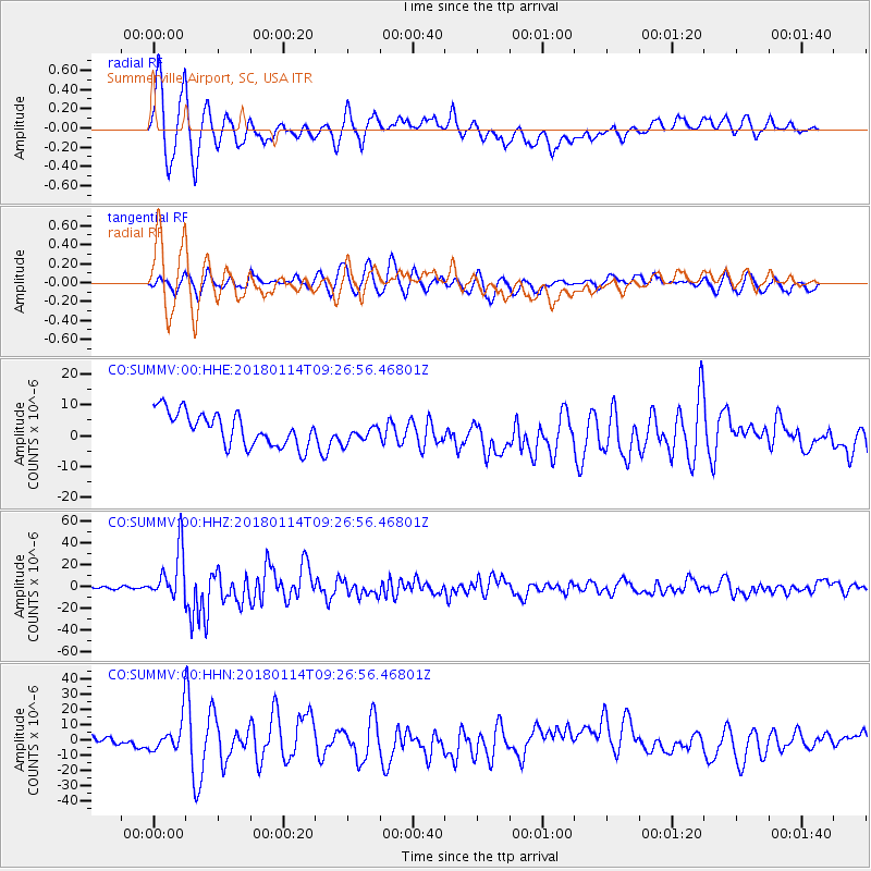
Signal To Noise
| Channel | StoN | STA | LTA |
| CO:SUMMV:00:HHZ:20180114T09:26:56.46801Z | 15.849506 | 2.2914937E-5 | 1.4457823E-6 |
| CO:SUMMV:00:HHN:20180114T09:26:56.46801Z | 1.7624177 | 1.0294997E-5 | 5.841406E-6 |
| CO:SUMMV:00:HHE:20180114T09:26:56.46801Z | 0.5851215 | 3.1440682E-6 | 5.3733593E-6 |
| Arrivals |
| Ps | 1.3 SECOND |
| PpPs | 5.1 SECOND |
| PsPs/PpSs | 6.4 SECOND |


