You are here: Home > Network List > CU - Caribbean Network (USGS) Stations List
> Station BBGH Gun Hill, Barbados > Earthquake Result Viewer
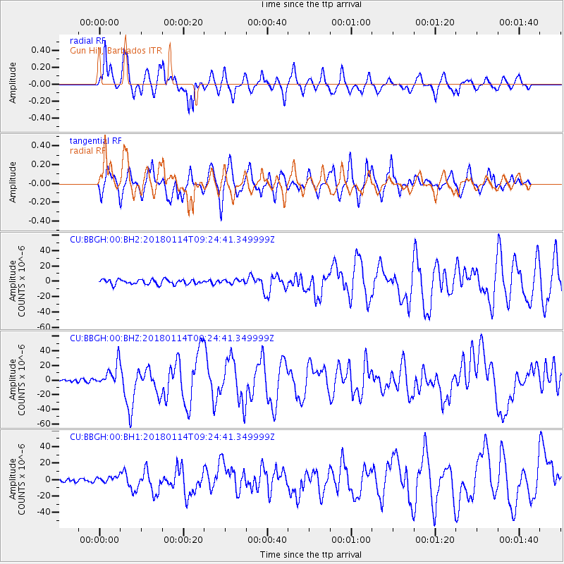
BBGH Gun Hill, Barbados - Earthquake Result Viewer
*The percent match for this event was below the threshold and hence no stack was calculated.
| Earthquake location: |
Near Coast Of Peru |
| Earthquake latitude/longitude: |
-15.8/-74.7 |
| Earthquake time(UTC): |
2018/01/14 (014) 09:18:45 GMT |
| Earthquake Depth: |
36 km |
| Earthquake Magnitude: |
7.1 mww |
| Earthquake Catalog/Contributor: |
NEIC PDE/us |
|
| Network: |
CU Caribbean Network (USGS) |
| Station: |
BBGH Gun Hill, Barbados |
| Lat/Lon: |
13.14 N/59.56 W |
| Elevation: |
180 m |
|
| Distance: |
32.4 deg |
| Az: |
28.419 deg |
| Baz: |
208.059 deg |
| Ray Param: |
$rayparam |
*The percent match for this event was below the threshold and hence was not used in the summary stack. |
|
| Radial Match: |
80.893234 % |
| Radial Bump: |
400 |
| Transverse Match: |
81.4255 % |
| Transverse Bump: |
400 |
| SOD ConfigId: |
2537391 |
| Insert Time: |
2018-01-28 09:19:32.789 +0000 |
| GWidth: |
2.5 |
| Max Bumps: |
400 |
| Tol: |
0.001 |
|
Signal To Noise
| Channel | StoN | STA | LTA |
| CU:BBGH:00:BHZ:20180114T09:24:41.349999Z | 7.832337 | 1.5974798E-5 | 2.0395955E-6 |
| CU:BBGH:00:BH1:20180114T09:24:41.349999Z | 1.6701696 | 3.7833656E-6 | 2.2652584E-6 |
| CU:BBGH:00:BH2:20180114T09:24:41.349999Z | 0.8010348 | 2.4515825E-6 | 3.0605192E-6 |
| Arrivals |
| Ps | |
| PpPs | |
| PsPs/PpSs | |


